Kulunda geodata
Kulunda (Altai Krai) is a populated place; located in Russia in Asia/Barnaul (GMT+7) time zone. With population of 15,345 people, there are 1070 cities with bigger population in this country. Compared to other cities in Russia, 65.8% of cities are located further ↑North; 79.1% of cities are located further ←West and 54.2% of cities have higher elevation than Kulunda. Note1


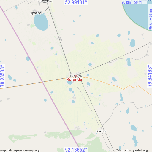
Kulunda GPS coordinates[2]
52° 33' 57.6" North, 78° 56' 18.6" East
| Map corner | latitude | longitude |
|---|---|---|
| Upper-left | 52.99131°, | 78.23538° |
| Center: | 52.566°, | 78.9385° |
| Lower-right: | 52.13652°, | 79.64163° |
| Map W x H: | 95×95 km | = 59×59mi |
| max Lat: | 73.50819° ⇑65.8% North |
| Kulunda: | 52.566° |
| min Lat: | ⇓34.2% South 41.28413° |
| min Long | Kulunda | max Long |
| -179.12198° | 78.9385° | 179.35046° |
| W 79.1%⇐ | ⇒20.9% E |
Elevation
Elevation of Kulunda is 136 m = 446 ft, and this is 66.6 m = 219 ft below average elevation for this country.
| Max E: |
2518 m = 8261 ft | 54.2% |
| Avg. | 202.6 m = 665 ft | |
| Kulunda | 136 m = 446 ft | |
Min E: |
-28 m = -92 ft | 45.8% |
See also: Russia elevation on elevation.city.
Geographical zone
Kulunda is located in North temperate zone (between Tropic of Cancer and the Arctic Circle). Distance of this North polar circle is 1556.4 km =967.1 mi to North.| Distance of | km | miles | from Kulunda |
|---|---|---|---|
| North Pole | 4162.3 | 2586.3 | to North |
| Arctic Circle | 1556.4 | 967.1 | to North |
| Tropic Cancer | 3238.9 | 2012.6 | to South |
| Equator | 5844.8 | 3631.8 | to South |


Nearby cities:
15 places around Kulunda: (largest is in red/bold)
• Bastan
86.7 km =53.9 mi,  155°
155°
• Blagoveshchenka
69.2 km =43 mi,  64°
64°
• Bursol’
74.8 km =46.5 mi,  333°
333°
• Gal’bshtadt
73.5 km =45.7 mi,  2°
2°
• Grishkovka
66 km =41 mi,  349°
349°
• Klyuchi
38.1 km =23.7 mi, 155°
• Kusak
73.1 km =45.4 mi,  359°
359°
• Nikolayevka
78.3 km =48.7 mi, 155°
• Podsosnovo
89.6 km =55.7 mi, 359°
• Rodino
85.9 km =53.4 mi,  95°
95°
• Severka
53.5 km =33.2 mi,  154°
154°
• Slavgorod
51.9 km =32.2 mi,  337°
337°
• Slavgorodskoye
54.4 km =33.8 mi, 338°
• Tabuny
25.5 km =15.8 mi, 336°
• Yarovoye
46.9 km =29.1 mi, 329°
Sources, notices
• [Note1] Compared only with cities in Russia existing in our database
• [Src1] Map data: © OpenStreetMap contributors (CC-BY-SA)
• [Src2] Other city data from geonames.org with taken over terms of usage.
• [Src3] Geographical zone / Annual Mean Temperature by Robert A. Rohde @ Wikipedia
