Gal’bshtadt geodata
Gal’bshtadt (Altai Krai) is a populated place; located in Russia in Asia/Barnaul (GMT+7) time zone. With population of 1,778 people, there are 4259 cities with bigger population in this country. Compared to other cities in Russia, 61.1% of cities are located further ↑North; 79.1% of cities are located further ←West and 52.1% of cities have higher elevation than Gal’bshtadt. Note1


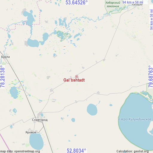
Gal’bshtadt GPS coordinates[2]
53° 13' 35.04" North, 78° 59' 4.2" East
| Map corner | latitude | longitude |
|---|---|---|
| Upper-left | 53.64526°, | 78.28138° |
| Center: | 53.2264°, | 78.9845° |
| Lower-right: | 52.8034°, | 79.68763° |
| Map W x H: | 93.6×93.6 km | = 58.2×58.2mi |
| max Lat: | 73.50819° ⇑61.1% North |
| Gal’bshtadt: | 53.2264° |
| min Lat: | ⇓38.9% South 41.28413° |
| min Long | Gal’bshtadt | max Long |
| -179.12198° | 78.9845° | 179.35046° |
| W 79.1%⇐ | ⇒20.9% E |
Elevation
Elevation of Gal’bshtadt is 140 m = 459 ft, and this is 62.6 m = 205 ft below average elevation for this country.
| Max E: |
2518 m = 8261 ft | 52.1% |
| Avg. | 202.6 m = 665 ft | |
| Gal’bshtadt | 140 m = 459 ft | |
Min E: |
-28 m = -92 ft | 47.9% |
See also: Russia elevation on elevation.city.
Geographical zone
Gal’bshtadt is located in North temperate zone (between Tropic of Cancer and the Arctic Circle). Distance of this North polar circle is 1483 km =921.5 mi to North.| Distance of | km | miles | from Gal’bshtadt |
|---|---|---|---|
| North Pole | 4088.8 | 2540.7 | to North |
| Arctic Circle | 1483 | 921.5 | to North |
| Tropic Cancer | 3312.3 | 2058.2 | to South |
| Equator | 5918.2 | 3677.4 | to South |


Nearby cities:
15 places around Gal’bshtadt: (largest is in red/bold)
• Blagoveshchenka
73.4 km =45.6 mi,  126°
126°
• Burla
45.2 km =28.1 mi,  285°
285°
• Bursol’
36.6 km =22.7 mi,  259°
259°
• Grishkovka
17.8 km =11.1 mi,  240°
240°
• Khabary
57.5 km =35.7 mi,  39°
39°
• Kusak
3.4 km =2.1 mi,  265°
265°
• Novopeschanoye
36.9 km =22.9 mi,  303°
303°
• Podsosnovo
16.8 km =10.4 mi,  344°
344°
• Polovinnoye
61.4 km =38.2 mi,  16°
16°
• Slavgorod
34.1 km =21.2 mi,  221°
221°
• Slavgorodskoye
32.2 km =20 mi, 224°
• Tabuny
51.6 km =32.1 mi,  194°
194°
• Ust’yanka
29.9 km =18.6 mi,  327°
327°
• Verkh-Suetka
71.2 km =44.2 mi,  83°
83°
• Yarovoye
42.8 km =26.6 mi, 219°
Sources, notices
• [Note1] Compared only with cities in Russia existing in our database
• [Src1] Map data: © OpenStreetMap contributors (CC-BY-SA)
• [Src2] Other city data from geonames.org with taken over terms of usage.
• [Src3] Geographical zone / Annual Mean Temperature by Robert A. Rohde @ Wikipedia
