Tabuny geodata
Tabuny (Altai Krai) is a populated place; located in Russia in Asia/Barnaul (GMT+7) time zone. With population of 3,950 people, there are 3142 cities with bigger population in this country. Compared to other cities in Russia, 64.2% of cities are located further ↑North; 79% of cities are located further ←West and 58.2% of cities have higher elevation than Tabuny. Note1


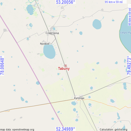
Tabuny GPS coordinates[2]
52° 46' 38.28" North, 78° 47' 22.56" East
| Map corner | latitude | longitude |
|---|---|---|
| Upper-left | 53.20056°, | 78.08648° |
| Center: | 52.7773°, | 78.7896° |
| Lower-right: | 52.34989°, | 79.49273° |
| Map W x H: | 94.6×94.6 km | = 58.8×58.8mi |
| max Lat: | 73.50819° ⇑64.2% North |
| Tabuny: | 52.7773° |
| min Lat: | ⇓35.8% South 41.28413° |
| min Long | Tabuny | max Long |
| -179.12198° | 78.7896° | 179.35046° |
| W 79%⇐ | ⇒21% E |
Elevation
Elevation of Tabuny is 128 m = 420 ft, and this is 74.6 m = 245 ft below average elevation for this country.
| Max E: |
2518 m = 8261 ft | 58.2% |
| Avg. | 202.6 m = 665 ft | |
| Tabuny | 128 m = 420 ft | |
Min E: |
-28 m = -92 ft | 41.8% |
See also: Russia elevation on elevation.city.
Geographical zone
Tabuny is located in North temperate zone (between Tropic of Cancer and the Arctic Circle). Distance of this North polar circle is 1532.9 km =952.5 mi to North.| Distance of | km | miles | from Tabuny |
|---|---|---|---|
| North Pole | 4138.8 | 2571.7 | to North |
| Arctic Circle | 1532.9 | 952.5 | to North |
| Tropic Cancer | 3262.4 | 2027.2 | to South |
| Equator | 5868.3 | 3646.4 | to South |


Nearby cities:
15 places around Tabuny: (largest is in red/bold)
• Blagoveshchenka
72.7 km =45.2 mi,  85°
85°
• Burla
69.3 km =43.1 mi,  333°
333°
• Bursol’
49.3 km =30.6 mi, 331°
• Gal’bshtadt
51.6 km =32.1 mi,  14°
14°
• Grishkovka
41.4 km =25.7 mi,  356°
356°
• Klyuchi
63.7 km =39.6 mi,  156°
156°
• Kulunda
25.5 km =15.8 mi, 156°
• Kusak
50.6 km =31.4 mi, 10°
• Novopeschanoye
72.5 km =45 mi,  345°
345°
• Podsosnovo
66.7 km =41.4 mi, 7°
• Severka
79 km =49.1 mi,  154°
154°
• Slavgorod
26.4 km =16.4 mi,  338°
338°
• Slavgorodskoye
28.9 km =18 mi, 340°
• Ust’yanka
75.2 km =46.7 mi, 357°
• Yarovoye
21.8 km =13.5 mi,  319°
319°
Sources, notices
• [Note1] Compared only with cities in Russia existing in our database
• [Src1] Map data: © OpenStreetMap contributors (CC-BY-SA)
• [Src2] Other city data from geonames.org with taken over terms of usage.
• [Src3] Geographical zone / Annual Mean Temperature by Robert A. Rohde @ Wikipedia
