Blagoveshchenka geodata
Blagoveshchenka (Altai Krai) is a populated place; located in Russia in Asia/Barnaul (GMT+7) time zone. With population of 12,319 people, there are 1247 cities with bigger population in this country. Compared to other cities in Russia, 63.9% of cities are located further ↑North; 79.4% of cities are located further ←West and 67.2% of cities have higher elevation than Blagoveshchenka. Note1


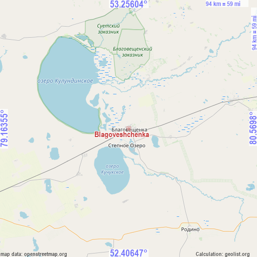
Blagoveshchenka GPS coordinates[2]
52° 49' 59.988" North, 79° 52' 0.012" East
| Map corner | latitude | longitude |
|---|---|---|
| Upper-left | 53.25604°, | 79.16355° |
| Center: | 52.83333°, | 79.86667° |
| Lower-right: | 52.40647°, | 80.5698° |
| Map W x H: | 94.5×94.5 km | = 58.7×58.7mi |
| max Lat: | 73.50819° ⇑63.9% North |
| Blagoveshchenka: | 52.83333° |
| min Lat: | ⇓36.1% South 41.28413° |
| min Long | Blagoveshchenka | max Long |
| -179.12198° | 79.86667° | 179.35046° |
| W 79.4%⇐ | ⇒20.6% E |
Elevation
Elevation of Blagoveshchenka is 109 m = 358 ft, and this is 93.6 m = 307 ft below average elevation for this country.
| Max E: |
2518 m = 8261 ft | 67.2% |
| Avg. | 202.6 m = 665 ft | |
| Blagoveshchenka | 109 m = 358 ft | |
Min E: |
-28 m = -92 ft | 32.8% |
See also: Russia elevation on elevation.city.
Geographical zone
Blagoveshchenka is located in North temperate zone (between Tropic of Cancer and the Arctic Circle). Distance of this North polar circle is 1526.7 km =948.6 mi to North.| Distance of | km | miles | from Blagoveshchenka |
|---|---|---|---|
| North Pole | 4132.5 | 2567.8 | to North |
| Arctic Circle | 1526.7 | 948.6 | to North |
| Tropic Cancer | 3268.6 | 2031 | to South |
| Equator | 5874.5 | 3650.2 | to South |


Nearby cities:
15 places around Blagoveshchenka: (largest is in red/bold)
• Bayevo
78 km =48.5 mi,  51°
51°
• Gal’bshtadt
73.4 km =45.6 mi,  306°
306°
• Grishkovka
82.5 km =51.3 mi,  295°
295°
• Klyuchi
79.9 km =49.6 mi,  216°
216°
• Kulunda
69.2 km =43 mi,  244°
244°
• Kusak
76 km =47.2 mi, 304°
• Podsosnovo
87.2 km =54.2 mi, 313°
• Rodino
43.7 km =27.2 mi,  148°
148°
• Severka
87.3 km =54.2 mi,  206°
206°
• Slavgorod
83.9 km =52.1 mi,  282°
282°
• Slavgorodskoye
84.6 km =52.6 mi, 284°
• Tabuny
72.7 km =45.2 mi,  265°
265°
• Verkh-Suetka
53.7 km =33.4 mi,  12°
12°
• Yarovoye
87 km =54.1 mi, 276°
• Zav’yalovo
70.7 km =43.9 mi,  89°
89°
Sources, notices
• [Note1] Compared only with cities in Russia existing in our database
• [Src1] Map data: © OpenStreetMap contributors (CC-BY-SA)
• [Src2] Other city data from geonames.org with taken over terms of usage.
• [Src3] Geographical zone / Annual Mean Temperature by Robert A. Rohde @ Wikipedia
