Shira geodata
Shira (Khakasiya Republic) is a populated place; located in Russia in Asia/Krasnoyarsk (GMT+7) time zone. With population of 9,358 people, there are 1605 cities with bigger population in this country. Compared to other cities in Russia, 51.1% of cities are located further ↑North; 85.7% of cities are located further ←West and 91.3% of cities have lower elevation than Shira. Note1


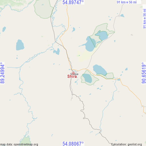
Shira GPS coordinates[2]
54° 29' 27.996" North, 89° 57' 11.016" East
| Map corner | latitude | longitude |
|---|---|---|
| Upper-left | 54.89747°, | 89.24994° |
| Center: | 54.49111°, | 89.95306° |
| Lower-right: | 54.08067°, | 90.65619° |
| Map W x H: | 90.8×90.8 km | = 56.4×56.4mi |
| max Lat: | 73.50819° ⇑51.1% North |
| Shira: | 54.49111° |
| min Lat: | ⇓48.9% South 41.28413° |
| min Long | Shira | max Long |
| -179.12198° | 89.95306° | 179.35046° |
| W 85.7%⇐ | ⇒14.3% E |
Elevation
Elevation of Shira is 485 m = 1591 ft, and this is 282.4 m = 927 ft above average elevation for this country.
| Max E: |
2518 m = 8261 ft | 8.7% |
| Shira | 485 m 1591 ft | |
| Avg. | 202.6 m = 665 ft | |
Min E: |
-28 m = -92 ft | 91.3% |
See also: Russia elevation on elevation.city.
Geographical zone
Shira is located in North temperate zone (between Tropic of Cancer and the Arctic Circle). Distance of this North polar circle is 1342.3 km =834.1 mi to North.| Distance of | km | miles | from Shira |
|---|---|---|---|
| North Pole | 3948.2 | 2453.3 | to North |
| Arctic Circle | 1342.3 | 834.1 | to North |
| Tropic Cancer | 3452.9 | 2145.5 | to South |
| Equator | 6058.8 | 3764.8 | to South |


Nearby cities:
15 places around Shira: (largest is in red/bold)
• Abakan
129.2 km =80.3 mi,  131°
131°
• Belogorsk
110.7 km =68.8 mi,  301°
301°
• Biskamzha
119.1 km =74 mi,  193°
193°
• Bograd
63.7 km =39.6 mi,  116°
116°
• Chernogorsk
114.1 km =70.9 mi, 130°
• Goryachegorsk
121 km =75.2 mi,  326°
326°
• Kommunar
46.2 km =28.7 mi,  249°
249°
• Krasnoturansk
106 km =65.9 mi,  100°
100°
• Sayansk
130.9 km =81.3 mi,  106°
106°
• Sharypovo
126.1 km =78.4 mi,  337°
337°
• Sorsk
57.5 km =35.7 mi,  160°
160°
• Tuim
16.9 km =10.5 mi,  181°
181°
• Ust’-Abakan
118.6 km =73.7 mi, 127°
• Uzhur
91.6 km =56.9 mi,  355°
355°
• Zhemchuzhnyy
13 km =8.1 mi,  86°
86°
Sources, notices
• [Note1] Compared only with cities in Russia existing in our database
• [Src1] Map data: © OpenStreetMap contributors (CC-BY-SA)
• [Src2] Other city data from geonames.org with taken over terms of usage.
• [Src3] Geographical zone / Annual Mean Temperature by Robert A. Rohde @ Wikipedia
