Kargat geodata
Kargat (Novosibirsk Oblast) is a populated place; located in Russia in Asia/Novosibirsk (GMT+7) time zone. With population of 10,881 people, there are 1390 cities with bigger population in this country. Compared to other cities in Russia, 55.2% of cities are located further ↓South; 79.4% of cities are located further ←West and 56.2% of cities have higher elevation than Kargat. Note1


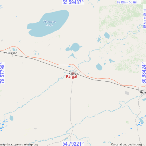
Kargat GPS coordinates[2]
55° 11' 44.016" North, 80° 16' 51.996" East
| Map corner | latitude | longitude |
|---|---|---|
| Upper-left | 55.59487°, | 79.57799° |
| Center: | 55.19556°, | 80.28111° |
| Lower-right: | 54.79221°, | 80.98424° |
| Map W x H: | 89.2×89.2 km | = 55.4×55.4mi |
| max Lat: | 73.50819° ⇑44.8% North |
| Kargat: | 55.19556° |
| min Lat: | ⇓55.2% South 41.28413° |
| min Long | Kargat | max Long |
| -179.12198° | 80.28111° | 179.35046° |
| W 79.4%⇐ | ⇒20.6% E |
Elevation
Elevation of Kargat is 132 m = 433 ft, and this is 70.6 m = 232 ft below average elevation for this country.
| Max E: |
2518 m = 8261 ft | 56.2% |
| Avg. | 202.6 m = 665 ft | |
| Kargat | 132 m = 433 ft | |
Min E: |
-28 m = -92 ft | 43.8% |
See also: Russia elevation on elevation.city.
Geographical zone
Kargat is located in North temperate zone (between Tropic of Cancer and the Arctic Circle). Distance of this North polar circle is 1264 km =785.4 mi to North.| Distance of | km | miles | from Kargat |
|---|---|---|---|
| North Pole | 3869.9 | 2404.6 | to North |
| Arctic Circle | 1264 | 785.4 | to North |
| Tropic Cancer | 3531.3 | 2194.2 | to South |
| Equator | 6137.2 | 3813.5 | to South |


Nearby cities:
15 places around Kargat: (largest is in red/bold)
• Barabinsk
123.2 km =76.6 mi,  278°
278°
• Chulym
44.3 km =27.5 mi,  103°
103°
• Katkovo
144 km =89.5 mi,  93°
93°
• Kochenëvo
123.7 km =76.9 mi, 98°
• Kochki
96.4 km =59.9 mi,  172°
172°
• Krasnozërskoye
150.7 km =93.6 mi,  206°
206°
• Krivodanovka
151.3 km =94 mi, 94°
• Krutikha
149.8 km =93.1 mi,  156°
156°
• Kuybyshev
127.1 km =79 mi, 282°
• Ordynskoye
138.9 km =86.3 mi,  131°
131°
• Pankrushikha
151.7 km =94.3 mi,  178°
178°
• Prokudskoye
140 km =87 mi, 98°
• Ubinskoye
40 km =24.9 mi,  287°
287°
• Yarkovo
154 km =95.7 mi,  106°
106°
• Zdvinsk
117.1 km =72.8 mi,  242°
242°
Sources, notices
• [Note1] Compared only with cities in Russia existing in our database
• [Src1] Map data: © OpenStreetMap contributors (CC-BY-SA)
• [Src2] Other city data from geonames.org with taken over terms of usage.
• [Src3] Geographical zone / Annual Mean Temperature by Robert A. Rohde @ Wikipedia
