Kochki geodata
Kochki (Novosibirsk Oblast) is a populated place; located in Russia in Asia/Novosibirsk (GMT+7) time zone. With population of 4,101 people, there are 3056 cities with bigger population in this country. Compared to other cities in Russia, 52.6% of cities are located further ↑North; 79.5% of cities are located further ←West and 54.9% of cities have lower elevation than Kochki. Note1


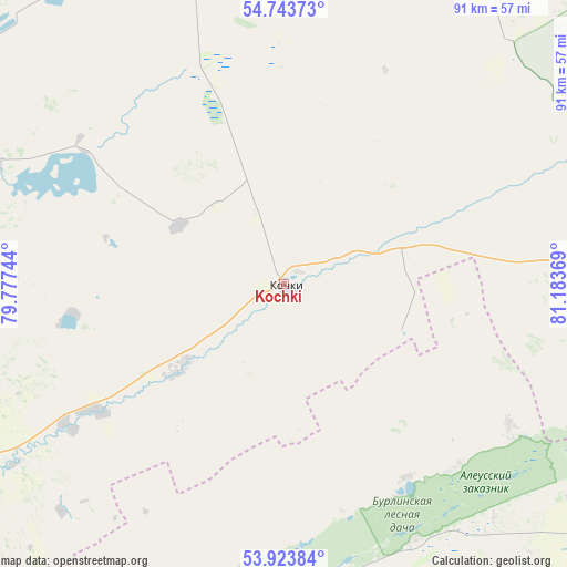
Kochki GPS coordinates[2]
54° 20' 8.988" North, 80° 28' 50.016" East
| Map corner | latitude | longitude |
|---|---|---|
| Upper-left | 54.74373°, | 79.77744° |
| Center: | 54.33583°, | 80.48056° |
| Lower-right: | 53.92384°, | 81.18369° |
| Map W x H: | 91.2×91.2 km | = 56.7×56.7mi |
| max Lat: | 73.50819° ⇑52.6% North |
| Kochki: | 54.33583° |
| min Lat: | ⇓47.4% South 41.28413° |
| min Long | Kochki | max Long |
| -179.12198° | 80.48056° | 179.35046° |
| W 79.5%⇐ | ⇒20.5% E |
Elevation
Elevation of Kochki is 156 m = 512 ft, and this is 46.6 m = 153 ft below average elevation for this country.
| Max E: |
2518 m = 8261 ft | 45.1% |
| Avg. | 202.6 m = 665 ft | |
| Kochki | 156 m = 512 ft | |
Min E: |
-28 m = -92 ft | 54.9% |
See also: Russia elevation on elevation.city.
Geographical zone
Kochki is located in North temperate zone (between Tropic of Cancer and the Arctic Circle). Distance of this North polar circle is 1359.6 km =844.8 mi to North.| Distance of | km | miles | from Kochki |
|---|---|---|---|
| North Pole | 3965.5 | 2464 | to North |
| Arctic Circle | 1359.6 | 844.8 | to North |
| Tropic Cancer | 3435.7 | 2134.8 | to South |
| Equator | 6041.6 | 3754.1 | to South |


Nearby cities:
15 places around Kochki: (largest is in red/bold)
• Bayevo
120 km =74.6 mi,  170°
170°
• Chulym
90.3 km =56.1 mi,  19°
19°
• Kamen’-na-Obi
82.9 km =51.5 mi,  137°
137°
• Kargat
96.4 km =59.9 mi,  352°
352°
• Khabary
100.3 km =62.3 mi,  218°
218°
• Krasnozërskoye
90 km =55.9 mi,  244°
244°
• Krutikha
63.2 km =39.3 mi,  131°
131°
• Ordynskoye
92 km =57.2 mi,  87°
87°
• Pankrushikha
56.8 km =35.3 mi,  189°
189°
• Polovinnoye
103.3 km =64.2 mi,  231°
231°
• Suzun
134.3 km =83.5 mi,  117°
117°
• Tyumentsevo
131 km =81.4 mi,  149°
149°
• Ubinskoye
119.5 km =74.3 mi,  334°
334°
• Verkh-Suetka
118.2 km =73.4 mi, 193°
• Zdvinsk
124.3 km =77.2 mi,  289°
289°
Sources, notices
• [Note1] Compared only with cities in Russia existing in our database
• [Src1] Map data: © OpenStreetMap contributors (CC-BY-SA)
• [Src2] Other city data from geonames.org with taken over terms of usage.
• [Src3] Geographical zone / Annual Mean Temperature by Robert A. Rohde @ Wikipedia
