Krutikha geodata
Krutikha (Altai Krai) is a populated place; located in Russia in Asia/Barnaul (GMT+7) time zone. With population of 4,294 people, there are 2958 cities with bigger population in this country. Compared to other cities in Russia, 55.6% of cities are located further ↑North; 79.7% of cities are located further ←West and 59.6% of cities have higher elevation than Krutikha. Note1


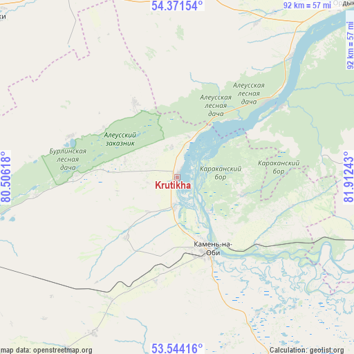
Krutikha GPS coordinates[2]
53° 57' 35.64" North, 81° 12' 33.48" East
| Map corner | latitude | longitude |
|---|---|---|
| Upper-left | 54.37154°, | 80.50618° |
| Center: | 53.9599°, | 81.2093° |
| Lower-right: | 53.54416°, | 81.91243° |
| Map W x H: | 92×92 km | = 57.2×57.2mi |
| max Lat: | 73.50819° ⇑55.6% North |
| Krutikha: | 53.9599° |
| min Lat: | ⇓44.4% South 41.28413° |
| min Long | Krutikha | max Long |
| -179.12198° | 81.2093° | 179.35046° |
| W 79.7%⇐ | ⇒20.3% E |
Elevation
Elevation of Krutikha is 125 m = 410 ft, and this is 77.6 m = 255 ft below average elevation for this country.
| Max E: |
2518 m = 8261 ft | 59.6% |
| Avg. | 202.6 m = 665 ft | |
| Krutikha | 125 m = 410 ft | |
Min E: |
-28 m = -92 ft | 40.4% |
See also: Russia elevation on elevation.city.
Geographical zone
Krutikha is located in North temperate zone (between Tropic of Cancer and the Arctic Circle). Distance of this North polar circle is 1401.4 km =870.8 mi to North.| Distance of | km | miles | from Krutikha |
|---|---|---|---|
| North Pole | 4007.3 | 2490 | to North |
| Arctic Circle | 1401.4 | 870.8 | to North |
| Tropic Cancer | 3393.9 | 2108.9 | to South |
| Equator | 5999.8 | 3728.1 | to South |


Nearby cities:
15 places around Krutikha: (largest is in red/bold)
• Bayevo
81.7 km =50.8 mi,  200°
200°
• Chulym
127.8 km =79.4 mi,  352°
352°
• Inya
108.7 km =67.5 mi,  117°
117°
• Kamen’-na-Obi
21 km =13 mi,  155°
155°
• Khabary
116.1 km =72.1 mi,  251°
251°
• Kochki
63.2 km =39.3 mi,  311°
311°
• Ordynskoye
63.7 km =39.6 mi,  44°
44°
• Pankrushikha
58.7 km =36.5 mi,  255°
255°
• Pervomayskiy
119.7 km =74.4 mi,  165°
165°
• Rebrikha
123.7 km =76.9 mi,  142°
142°
• Shelabolikha
110.8 km =68.8 mi, 123°
• Suzun
74.9 km =46.5 mi,  105°
105°
• Tyumentsevo
73.4 km =45.6 mi, 164°
• Verkh-Suetka
105.8 km =65.7 mi,  226°
226°
• Zav’yalovo
126.2 km =78.4 mi,  188°
188°
Sources, notices
• [Note1] Compared only with cities in Russia existing in our database
• [Src1] Map data: © OpenStreetMap contributors (CC-BY-SA)
• [Src2] Other city data from geonames.org with taken over terms of usage.
• [Src3] Geographical zone / Annual Mean Temperature by Robert A. Rohde @ Wikipedia
