Karabinka geodata
Karabinka (Altai Krai) is a populated place; located in Russia in Asia/Barnaul (GMT+7) time zone. With population of 1,000 people, there are 4627 cities with bigger population in this country. Compared to other cities in Russia, 64.9% of cities are located further ↑North; 84% of cities are located further ←West and 73.5% of cities have lower elevation than Karabinka. Note1


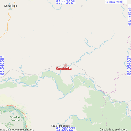
Karabinka GPS coordinates[2]
52° 41' 18.6" North, 86° 15' 6.12" East
| Map corner | latitude | longitude |
|---|---|---|
| Upper-left | 53.11262°, | 85.54858° |
| Center: | 52.6885°, | 86.2517° |
| Lower-right: | 52.26022°, | 86.95483° |
| Map W x H: | 94.8×94.8 km | = 58.9×58.9mi |
| max Lat: | 73.50819° ⇑64.9% North |
| Karabinka: | 52.6885° |
| min Lat: | ⇓35.1% South 41.28413° |
| min Long | Karabinka | max Long |
| -179.12198° | 86.2517° | 179.35046° |
| W 84%⇐ | ⇒16% E |
Elevation
Elevation of Karabinka is 210 m = 689 ft, and this is 7.4 m = 24 ft above average elevation for this country.
| Max E: |
2518 m = 8261 ft | 26.5% |
| Karabinka | 210 m 689 ft | |
| Avg. | 202.6 m = 665 ft | |
Min E: |
-28 m = -92 ft | 73.5% |
See also: Russia elevation on elevation.city.
Geographical zone
Karabinka is located in North temperate zone (between Tropic of Cancer and the Arctic Circle). Distance of this North polar circle is 1542.8 km =958.7 mi to North.| Distance of | km | miles | from Karabinka |
|---|---|---|---|
| North Pole | 4148.6 | 2577.8 | to North |
| Arctic Circle | 1542.8 | 958.7 | to North |
| Tropic Cancer | 3252.5 | 2021 | to South |
| Equator | 5858.4 | 3640.2 | to South |


Nearby cities:
15 places around Karabinka: (largest is in red/bold)
• Berëzovka
47.2 km =29.3 mi,  217°
217°
• Bystryanka
53.1 km =33 mi,  212°
212°
• Dmitriyevka
52.5 km =32.6 mi,  121°
121°
• Krasnogorskoye
43.9 km =27.3 mi,  184°
184°
• Neninka
4 km =2.5 mi,  244°
244°
• Novikovo
20.8 km =12.9 mi,  249°
249°
• Pushtulim
58.4 km =36.3 mi,  11°
11°
• Solton
23 km =14.3 mi,  41°
41°
• Souskanikha
23.7 km =14.7 mi, 235°
• Srostki
47.8 km =29.7 mi,  231°
231°
• Stan-Bekhtemir
43.2 km =26.8 mi,  257°
257°
• Sukhaya Chemrovka
57.9 km =36 mi,  273°
273°
• Usyatskoye
35.7 km =22.2 mi, 247°
• Verkh-Marushka
49 km =30.4 mi,  301°
301°
• Verkhniy Bekhtemir
24.6 km =15.3 mi,  290°
290°
Sources, notices
• [Note1] Compared only with cities in Russia existing in our database
• [Src1] Map data: © OpenStreetMap contributors (CC-BY-SA)
• [Src2] Other city data from geonames.org with taken over terms of usage.
• [Src3] Geographical zone / Annual Mean Temperature by Robert A. Rohde @ Wikipedia
