Cherepanovo geodata
Cherepanovo (Novosibirsk Oblast) is a populated place; located in Russia in Asia/Novosibirsk (GMT+7) time zone. With population of 20,125 people, there are 854 cities with bigger population in this country. Compared to other cities in Russia, 53.2% of cities are located further ↑North; 80.8% of cities are located further ←West and 82.2% of cities have lower elevation than Cherepanovo. Note1


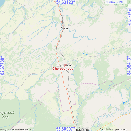
Cherepanovo GPS coordinates[2]
54° 13' 19.92" North, 83° 22' 51.6" East
| Map corner | latitude | longitude |
|---|---|---|
| Upper-left | 54.63123°, | 82.67788° |
| Center: | 54.2222°, | 83.381° |
| Lower-right: | 53.80907°, | 84.08413° |
| Map W x H: | 91.4×91.4 km | = 56.8×56.8mi |
| max Lat: | 73.50819° ⇑53.2% North |
| Cherepanovo: | 54.2222° |
| min Lat: | ⇓46.8% South 41.28413° |
| min Long | Cherepanovo | max Long |
| -179.12198° | 83.381° | 179.35046° |
| W 80.8%⇐ | ⇒19.2% E |
Elevation
Elevation of Cherepanovo is 276 m = 906 ft, and this is 73.4 m = 241 ft above average elevation for this country.
| Max E: |
2518 m = 8261 ft | 17.8% |
| Cherepanovo | 276 m 906 ft | |
| Avg. | 202.6 m = 665 ft | |
Min E: |
-28 m = -92 ft | 82.2% |
See also: Russia elevation on elevation.city.
Geographical zone
Cherepanovo is located in North temperate zone (between Tropic of Cancer and the Arctic Circle). Distance of this North polar circle is 1372.2 km =852.6 mi to North.| Distance of | km | miles | from Cherepanovo |
|---|---|---|---|
| North Pole | 3978.1 | 2471.9 | to North |
| Arctic Circle | 1372.2 | 852.6 | to North |
| Tropic Cancer | 3423 | 2127 | to South |
| Equator | 6028.9 | 3746.2 | to South |


Nearby cities:
15 places around Cherepanovo: (largest is in red/bold)
• Akademgorodok
72.3 km =44.9 mi,  345°
345°
• Baryshevo
82.6 km =51.3 mi, 351°
• Berdsk
62 km =38.5 mi,  342°
342°
• Dorogino
15.8 km =9.8 mi, 345°
• Iskitim
46.3 km =28.8 mi, 353°
• Kol’tsovo
80.6 km =50.1 mi, 350°
• Krasnoobsk
81.5 km =50.6 mi, 342°
• Linëvo
26.3 km =16.3 mi,  359°
359°
• Listvyanskiy
25.4 km =15.8 mi,  17°
17°
• Maslyanino
55.5 km =34.5 mi,  75°
75°
• Pervomayskoye
69.6 km =43.2 mi,  143°
143°
• Sibirskiy
75.8 km =47.1 mi,  160°
160°
• Tal’menka
46.5 km =28.9 mi, 164°
• Verkh-Tula
83.3 km =51.8 mi,  332°
332°
• Yarkovo
82.2 km =51.1 mi,  322°
322°
Sources, notices
• [Note1] Compared only with cities in Russia existing in our database
• [Src1] Map data: © OpenStreetMap contributors (CC-BY-SA)
• [Src2] Other city data from geonames.org with taken over terms of usage.
• [Src3] Geographical zone / Annual Mean Temperature by Robert A. Rohde @ Wikipedia
