Bazoy geodata
Bazoy (Tomsk Oblast) is a populated place; located in Russia in Asia/Tomsk (GMT+7) time zone. With population of 567 people, there are 4920 cities with bigger population in this country. Compared to other cities in Russia, 62.6% of cities are located further ↓South; 80.8% of cities are located further ←West and 71% of cities have higher elevation than Bazoy. Note1


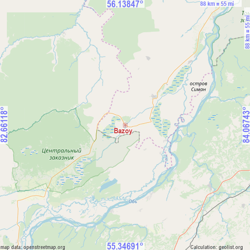
Bazoy GPS coordinates[2]
55° 44' 40.92" North, 83° 21' 51.48" East
| Map corner | latitude | longitude |
|---|---|---|
| Upper-left | 56.13847°, | 82.66118° |
| Center: | 55.7447°, | 83.3643° |
| Lower-right: | 55.34691°, | 84.06743° |
| Map W x H: | 88×88 km | = 54.7×54.7mi |
| max Lat: | 73.50819° ⇑37.4% North |
| Bazoy: | 55.7447° |
| min Lat: | ⇓62.6% South 41.28413° |
| min Long | Bazoy | max Long |
| -179.12198° | 83.3643° | 179.35046° |
| W 80.8%⇐ | ⇒19.2% E |
Elevation
Elevation of Bazoy is 100 m = 328 ft, and this is 102.6 m = 337 ft below average elevation for this country.
| Max E: |
2518 m = 8261 ft | 71% |
| Avg. | 202.6 m = 665 ft | |
| Bazoy | 100 m = 328 ft | |
Min E: |
-28 m = -92 ft | 29% |
See also: Russia elevation on elevation.city.
Geographical zone
Bazoy is located in North temperate zone (between Tropic of Cancer and the Arctic Circle). Distance of this North polar circle is 1202.9 km =747.4 mi to North.| Distance of | km | miles | from Bazoy |
|---|---|---|---|
| North Pole | 3808.8 | 2366.7 | to North |
| Arctic Circle | 1202.9 | 747.4 | to North |
| Tropic Cancer | 3592.3 | 2232.2 | to South |
| Equator | 6198.2 | 3851.4 | to South |


Nearby cities:
15 places around Bazoy: (largest is in red/bold)
• Bolotnoye
65.3 km =40.6 mi,  97°
97°
• Bol’shoy Oyësh
65.6 km =40.8 mi,  219°
219°
• Dubrovino
30.7 km =19.1 mi,  188°
188°
• Gornyy
77.9 km =48.4 mi,  153°
153°
• Kolyvan’
62.7 km =39 mi, 218°
• Kozhevnikovo
68.5 km =42.6 mi,  33°
33°
• Krivodanovka
85.6 km =53.2 mi,  211°
211°
• Kudryashovskiy
81 km =50.3 mi, 207°
• Mochishche
66.9 km =41.6 mi, 193°
• Moshkovo
51.3 km =31.9 mi,  162°
162°
• Novosibirsk
82.8 km =51.4 mi,  199°
199°
• Sadovyy
72.2 km =44.9 mi, 200°
• Sokur
59.6 km =37 mi,  182°
182°
• Stantsionno-Oyashinskiy
42.3 km =26.3 mi,  136°
136°
• Tashara
26.6 km =16.5 mi, 160°
Sources, notices
• [Note1] Compared only with cities in Russia existing in our database
• [Src1] Map data: © OpenStreetMap contributors (CC-BY-SA)
• [Src2] Other city data from geonames.org with taken over terms of usage.
• [Src3] Geographical zone / Annual Mean Temperature by Robert A. Rohde @ Wikipedia
