Gornyy geodata
Gornyy (Novosibirsk Oblast) is a populated place; located in Russia in Asia/Novosibirsk (GMT+7) time zone. With population of 9,808 people, there are 1539 cities with bigger population in this country. Compared to other cities in Russia, 54.6% of cities are located further ↓South; 81.4% of cities are located further ←West and 79.6% of cities have lower elevation than Gornyy. Note1


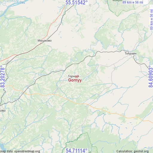
Gornyy GPS coordinates[2]
55° 6' 55.08" North, 83° 54' 21.24" East
| Map corner | latitude | longitude |
|---|---|---|
| Upper-left | 55.51542°, | 83.20278° |
| Center: | 55.1153°, | 83.9059° |
| Lower-right: | 54.71114°, | 84.60903° |
| Map W x H: | 89.4×89.4 km | = 55.6×55.6mi |
| max Lat: | 73.50819° ⇑45.4% North |
| Gornyy: | 55.1153° |
| min Lat: | ⇓54.6% South 41.28413° |
| min Long | Gornyy | max Long |
| -179.12198° | 83.9059° | 179.35046° |
| W 81.4%⇐ | ⇒18.6% E |
Elevation
Elevation of Gornyy is 245 m = 804 ft, and this is 42.4 m = 139 ft above average elevation for this country.
| Max E: |
2518 m = 8261 ft | 20.4% |
| Gornyy | 245 m 804 ft | |
| Avg. | 202.6 m = 665 ft | |
Min E: |
-28 m = -92 ft | 79.6% |
See also: Russia elevation on elevation.city.
Geographical zone
Gornyy is located in North temperate zone (between Tropic of Cancer and the Arctic Circle). Distance of this North polar circle is 1272.9 km =790.9 mi to North.| Distance of | km | miles | from Gornyy |
|---|---|---|---|
| North Pole | 3878.8 | 2410.2 | to North |
| Arctic Circle | 1272.9 | 790.9 | to North |
| Tropic Cancer | 3522.3 | 2188.7 | to South |
| Equator | 6128.2 | 3807.9 | to South |


Nearby cities:
15 places around Gornyy: (largest is in red/bold)
• Akademgorodok
58.8 km =36.5 mi,  240°
240°
• Baryshevo
49.4 km =30.7 mi,  249°
249°
• Berdsk
65.4 km =40.6 mi,  232°
232°
• Dubrovino
55.6 km =34.5 mi,  315°
315°
• Kol’tsovo
50.2 km =31.2 mi, 246°
• Krasnoobsk
62.2 km =38.6 mi, 249°
• Mochishche
50 km =31.1 mi,  275°
275°
• Moshkovo
28.2 km =17.5 mi, 318°
• Novolugovoye
52.7 km =32.7 mi, 253°
• Novosibirsk
62.4 km =38.8 mi,  262°
262°
• Sadovyy
59.8 km =37.2 mi,  272°
272°
• Sokur
38.7 km =24 mi,  285°
285°
• Stantsionno-Oyashinskiy
39.4 km =24.5 mi,  352°
352°
• Tashara
51.5 km =32 mi,  330°
330°
• Toguchin
33.3 km =20.7 mi,  66°
66°
Sources, notices
• [Note1] Compared only with cities in Russia existing in our database
• [Src1] Map data: © OpenStreetMap contributors (CC-BY-SA)
• [Src2] Other city data from geonames.org with taken over terms of usage.
• [Src3] Geographical zone / Annual Mean Temperature by Robert A. Rohde @ Wikipedia
