Moshkovo geodata
Moshkovo (Novosibirsk Oblast) is a populated place; located in Russia in Asia/Novosibirsk (GMT+7) time zone. With population of 10,541 people, there are 1441 cities with bigger population in this country. Compared to other cities in Russia, 56.1% of cities are located further ↓South; 81.1% of cities are located further ←West and 74.8% of cities have lower elevation than Moshkovo. Note1


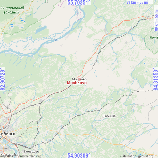
Moshkovo GPS coordinates[2]
55° 18' 19.08" North, 83° 36' 37.44" East
| Map corner | latitude | longitude |
|---|---|---|
| Upper-left | 55.70351°, | 82.90728° |
| Center: | 55.3053°, | 83.6104° |
| Lower-right: | 54.90306°, | 84.31353° |
| Map W x H: | 89×89 km | = 55.3×55.3mi |
| max Lat: | 73.50819° ⇑43.9% North |
| Moshkovo: | 55.3053° |
| min Lat: | ⇓56.1% South 41.28413° |
| min Long | Moshkovo | max Long |
| -179.12198° | 83.6104° | 179.35046° |
| W 81.1%⇐ | ⇒18.9% E |
Elevation
Elevation of Moshkovo is 216 m = 709 ft, and this is 13.4 m = 44 ft above average elevation for this country.
| Max E: |
2518 m = 8261 ft | 25.2% |
| Moshkovo | 216 m 709 ft | |
| Avg. | 202.6 m = 665 ft | |
Min E: |
-28 m = -92 ft | 74.8% |
See also: Russia elevation on elevation.city.
Geographical zone
Moshkovo is located in North temperate zone (between Tropic of Cancer and the Arctic Circle). Distance of this North polar circle is 1251.8 km =777.8 mi to North.| Distance of | km | miles | from Moshkovo |
|---|---|---|---|
| North Pole | 3857.7 | 2397.1 | to North |
| Arctic Circle | 1251.8 | 777.8 | to North |
| Tropic Cancer | 3543.5 | 2201.8 | to South |
| Equator | 6149.4 | 3821.1 | to South |


Nearby cities:
15 places around Moshkovo: (largest is in red/bold)
• Baryshevo
47.4 km =29.5 mi,  215°
215°
• Bazoy
51.3 km =31.9 mi,  342°
342°
• Bol’shoy Oyësh
57.2 km =35.5 mi,  267°
267°
• Dubrovino
27.4 km =17 mi,  312°
312°
• Gornyy
28.2 km =17.5 mi,  138°
138°
• Kolyvan’
55.1 km =34.2 mi, 270°
• Kol’tsovo
49.1 km =30.5 mi,  213°
213°
• Mochishche
35 km =21.7 mi,  242°
242°
• Novolugovoye
48.1 km =29.9 mi, 221°
• Novosibirsk
52 km =32.3 mi, 235°
• Sadovyy
45 km =28 mi,  245°
245°
• Sokur
21.3 km =13.2 mi, 239°
• Stantsionno-Oyashinskiy
22.4 km =13.9 mi,  37°
37°
• Tashara
24.7 km =15.3 mi,  345°
345°
• Toguchin
49.7 km =30.9 mi,  99°
99°
Sources, notices
• [Note1] Compared only with cities in Russia existing in our database
• [Src1] Map data: © OpenStreetMap contributors (CC-BY-SA)
• [Src2] Other city data from geonames.org with taken over terms of usage.
• [Src3] Geographical zone / Annual Mean Temperature by Robert A. Rohde @ Wikipedia
