Stantsionno-Oyashinskiy geodata
Stantsionno-Oyashinskiy (Novosibirsk Oblast) is a populated place; located in Russia in Asia/Novosibirsk (GMT+7) time zone. With population of 4,689 people, there are 2787 cities with bigger population in this country. Compared to other cities in Russia, 57.7% of cities are located further ↓South; 81.3% of cities are located further ←West and 62.4% of cities have lower elevation than Stantsionno-Oyashinskiy. Note1
Current local time in Stantsionno-Oyashinskiy:
08:43 PM, MondayDifference from your time zone: hours


Stantsionno-Oyashinskiy GPS coordinates[2]
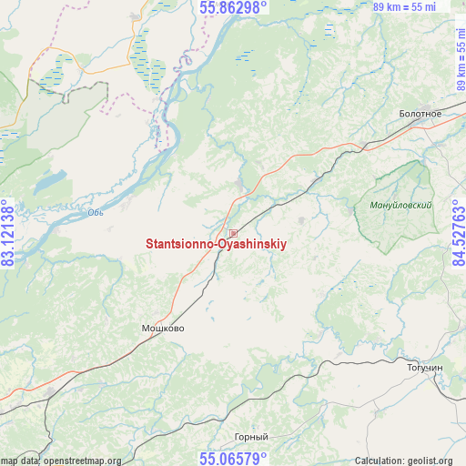
55° 27' 59.04" North, 83° 49' 28.2" East
| Map corner | latitude | longitude |
|---|---|---|
| Upper-left | 55.86298°, | 83.12138° |
| Center: | 55.4664°, | 83.8245° |
| Lower-right: | 55.06579°, | 84.52763° |
| Map W x H: | 88.6×88.6 km | = 55.1×55.1mi |
| max Lat: | 73.50819° ⇑42.3% North |
| Stantsionno-Oyashinskiy: | 55.4664° |
| min Lat: | ⇓57.7% South 41.28413° |
| min Long | Stantsionno-Oya | max Long |
| -179.12198° | 83.8245° | 179.35046° |
| W 81.3%⇐ | ⇒18.7% E |
Elevation
Elevation of Stantsionno-Oyashinskiy is 175 m = 574 ft, and this is 27.6 m = 91 ft below average elevation for this country.
| Max E: |
2518 m = 8261 ft | 37.6% |
| Avg. | 202.6 m = 665 ft | |
| Stantsionno-Oyashinskiy | 175 m = 574 ft | |
Min E: |
-28 m = -92 ft | 62.4% |
See also: Russia elevation on elevation.city.
Geographical zone
Stantsionno-Oyashinskiy is located in North temperate zone (between Tropic of Cancer and the Arctic Circle). Distance of this North polar circle is 1233.9 km =766.7 mi to North.| Distance of | km | miles | from Stantsionno-Oyashinskiy |
|---|---|---|---|
| North Pole | 3839.8 | 2385.9 | to North |
| Arctic Circle | 1233.9 | 766.7 | to North |
| Tropic Cancer | 3561.4 | 2213 | to South |
| Equator | 6167.3 | 3832.2 | to South |


Nearby cities:
15 places around Stantsionno-Oyashinskiy: (largest is in red/bold)
• Baryshevo
69.8 km =43.4 mi,  215°
215°
• Bazoy
42.3 km =26.3 mi,  316°
316°
• Bolotnoye
42.7 km =26.5 mi,  57°
57°
• Dubrovino
33.6 km =20.9 mi,  271°
271°
• Gornyy
39.4 km =24.5 mi,  172°
172°
• Kolyvan’
70.9 km =44.1 mi,  255°
255°
• Kol’tsovo
71.5 km =44.4 mi,  214°
214°
• Mochishche
56.1 km =34.9 mi,  232°
232°
• Moshkovo
22.4 km =13.9 mi, 217°
• Novolugovoye
70.5 km =43.8 mi, 219°
• Sadovyy
65.6 km =40.8 mi,  235°
235°
• Sokur
42.9 km =26.7 mi, 228°
• Tashara
20.7 km =12.9 mi,  286°
286°
• Toguchin
43.8 km =27.2 mi,  125°
125°
• Yurga
72.5 km =45 mi,  66°
66°
Sources, notices
• [Note1] Compared only with cities in Russia existing in our database
• [Src1] Map data: © OpenStreetMap contributors (CC-BY-SA)
• [Src2] Other city data from geonames.org with taken over terms of usage.
• [Src3] Geographical zone / Annual Mean Temperature by Robert A. Rohde @ Wikipedia
