Mortka geodata
Mortka (Khanty-Mansia) is a populated place; located in Russia in Asia/Yekaterinburg (GMT+5) time zone. With population of 3,698 people, there are 3271 cities with bigger population in this country. Compared to other cities in Russia, 87.3% of cities are located further ↓South; 76.3% of cities are located further ←West and 76.7% of cities have higher elevation than Mortka. Note1


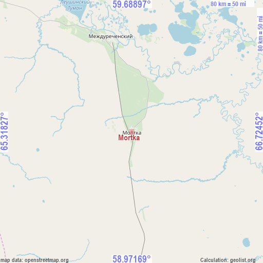
Mortka GPS coordinates[2]
59° 19' 55.992" North, 66° 1' 17.004" East
| Map corner | latitude | longitude |
|---|---|---|
| Upper-left | 59.68897°, | 65.31827° |
| Center: | 59.33222°, | 66.02139° |
| Lower-right: | 58.97169°, | 66.72452° |
| Map W x H: | 79.8×79.8 km | = 49.6×49.6mi |
| max Lat: | 73.50819° ⇑12.7% North |
| Mortka: | 59.33222° |
| min Lat: | ⇓87.3% South 41.28413° |
| min Long | Mortka | max Long |
| -179.12198° | 66.02139° | 179.35046° |
| W 76.3%⇐ | ⇒23.7% E |
Elevation
Elevation of Mortka is 82 m = 269 ft, and this is 120.6 m = 396 ft below average elevation for this country.
| Max E: |
2518 m = 8261 ft | 76.7% |
| Avg. | 202.6 m = 665 ft | |
| Mortka | 82 m = 269 ft | |
Min E: |
-28 m = -92 ft | 23.3% |
See also: Russia elevation on elevation.city.
Geographical zone
Mortka is located in North temperate zone (between Tropic of Cancer and the Arctic Circle). Distance of this North polar circle is 804 km =499.6 mi to North.| Distance of | km | miles | from Mortka |
|---|---|---|---|
| North Pole | 3409.9 | 2118.8 | to North |
| Arctic Circle | 804 | 499.6 | to North |
| Tropic Cancer | 3991.2 | 2480 | to South |
| Equator | 6597.1 | 4099.2 | to South |


Nearby cities:
15 places around Mortka: (largest is in red/bold)
• Azanka
160.3 km =99.6 mi,  206°
206°
• Irtyshskiy
164.6 km =102.3 mi,  132°
132°
• Kondinskoye
85.9 km =53.4 mi,  65°
65°
• Kuminskiy
80.3 km =49.9 mi,  157°
157°
• Mendeleyevo
184.6 km =114.7 mi, 134°
• Mezhdurechenskiy
30.2 km =18.8 mi,  350°
350°
• Nizhnyaya Tavda
184.7 km =114.8 mi,  177°
177°
• Sumkino
190 km =118.1 mi,  135°
135°
• Tabory
123.7 km =76.9 mi,  223°
223°
• Tavda
149.8 km =93.1 mi,  196°
196°
• Tobol’sk
180.2 km =112 mi, 134°
• Turinsk
196.2 km =121.9 mi, 223°
• Turtas
182.8 km =113.6 mi,  103°
103°
• Uray
112.5 km =69.9 mi,  322°
322°
• Uvat
164.4 km =102.2 mi, 97°
Sources, notices
• [Note1] Compared only with cities in Russia existing in our database
• [Src1] Map data: © OpenStreetMap contributors (CC-BY-SA)
• [Src2] Other city data from geonames.org with taken over terms of usage.
• [Src3] Geographical zone / Annual Mean Temperature by Robert A. Rohde @ Wikipedia
