Mezhdurechenskiy geodata
Mezhdurechenskiy (Khanty-Mansia) is a populated place; located in Russia in Asia/Yekaterinburg (GMT+5) time zone. With population of 11,121 people, there are 1359 cities with bigger population in this country. Compared to other cities in Russia, 88.1% of cities are located further ↓South; 76.3% of cities are located further ←West and 87.5% of cities have higher elevation than Mezhdurechenskiy. Note1


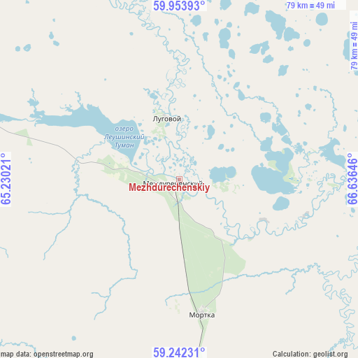
Mezhdurechenskiy GPS coordinates[2]
59° 36' 0" North, 65° 55' 59.988" East
| Map corner | latitude | longitude |
|---|---|---|
| Upper-left | 59.95393°, | 65.23021° |
| Center: | 59.6°, | 65.93333° |
| Lower-right: | 59.24231°, | 66.63646° |
| Map W x H: | 79.1×79.1 km | = 49.2×49.2mi |
| max Lat: | 73.50819° ⇑11.9% North |
| Mezhdurechenskiy: | 59.6° |
| min Lat: | ⇓88.1% South 41.28413° |
| min Long | Mezhdurechenski | max Long |
| -179.12198° | 65.93333° | 179.35046° |
| W 76.3%⇐ | ⇒23.7% E |
Elevation
Elevation of Mezhdurechenskiy is 38 m = 125 ft, and this is 164.6 m = 540 ft below average elevation for this country.
| Max E: |
2518 m = 8261 ft | 87.5% |
| Avg. | 202.6 m = 665 ft | |
| Mezhdurechenskiy | 38 m = 125 ft | |
Min E: |
-28 m = -92 ft | 12.5% |
See also: Russia elevation on elevation.city.
Geographical zone
Mezhdurechenskiy is located in North temperate zone (between Tropic of Cancer and the Arctic Circle). Distance of this North polar circle is 774.3 km =481.1 mi to North.| Distance of | km | miles | from Mezhdurechenskiy |
|---|---|---|---|
| North Pole | 3380.2 | 2100.4 | to North |
| Arctic Circle | 774.3 | 481.1 | to North |
| Tropic Cancer | 4021 | 2498.5 | to South |
| Equator | 6626.9 | 4117.8 | to South |


Nearby cities:
15 places around Mezhdurechenskiy: (largest is in red/bold)
• Azanka
185.5 km =115.3 mi,  200°
200°
• Gari
203 km =126.1 mi,  264°
264°
• Irtyshskiy
189 km =117.4 mi,  138°
138°
• Kondinskoye
83.2 km =51.7 mi,  86°
86°
• Kuminskiy
109.9 km =68.3 mi,  160°
160°
• Mendeleyevo
209.5 km =130.2 mi, 139°
• Mortka
30.2 km =18.8 mi,  170°
170°
• Nizhnyaya Tavda
214.7 km =133.4 mi,  176°
176°
• Sumkino
215.2 km =133.7 mi, 140°
• Tabory
143.8 km =89.4 mi,  213°
213°
• Tavda
177.3 km =110.2 mi,  192°
192°
• Tobol’sk
205.1 km =127.4 mi, 139°
• Turtas
196.1 km =121.9 mi,  112°
112°
• Uray
86.9 km =54 mi,  312°
312°
• Uvat
175 km =108.7 mi, 106°
Sources, notices
• [Note1] Compared only with cities in Russia existing in our database
• [Src1] Map data: © OpenStreetMap contributors (CC-BY-SA)
• [Src2] Other city data from geonames.org with taken over terms of usage.
• [Src3] Geographical zone / Annual Mean Temperature by Robert A. Rohde @ Wikipedia
