Viksäter geodata
Viksäter (Stockholm) is a populated place; located in Sweden in Europe/Stockholm (GMT+2) time zone. With population of 859 people, there are 919 cities with bigger population in this country. Compared to other cities in Sweden, 57.8% of cities are located further ↓South; 80.5% of cities are located further ←West and 57.9% of cities have lower elevation than Viksäter. Note1


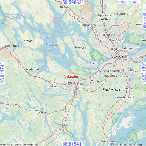
Viksäter GPS coordinates[2]
59° 14' 27.276" North, 17° 36' 53.496" East
| Map corner | latitude | longitude |
|---|---|---|
| Upper-left | 59.59862°, | 16.91174° |
| Center: | 59.24091°, | 17.61486° |
| Lower-right: | 58.87941°, | 18.31799° |
| Map W x H: | 80×80 km | = 49.7×49.7mi |
| max Lat: | 67.85572° ⇑42.2% North |
| Viksäter: | 59.24091° |
| min Lat: | ⇓57.8% South 55.34337° |
| min Long | Viksäter | max Long |
| 11.1712° | 17.61486° | 24.13676° |
| W 80.5%⇐ | ⇒19.5% E |
Elevation
Elevation of Viksäter is 65 m = 213 ft, and this is 17.6 m = 58 ft below average elevation for this country.
| Max E: |
663 m = 2175 ft | 42.1% |
| Avg. | 82.6 m = 271 ft | |
| Viksäter | 65 m = 213 ft | |
Min E: |
-1 m = -3 ft | 57.9% |
See also: Sweden elevation on elevation.city.
Geographical zone
Viksäter is located in North temperate zone (between Tropic of Cancer and the Arctic Circle). Distance of this North polar circle is 814.2 km =505.9 mi to North.| Distance of | km | miles | from Viksäter |
|---|---|---|---|
| North Pole | 3420.1 | 2125.2 | to North |
| Arctic Circle | 814.2 | 505.9 | to North |
| Tropic Cancer | 3981.1 | 2473.7 | to South |
| Equator | 6587 | 4093 | to South |


Nearby cities:
15 places around Viksäter: (largest is in red/bold)
• Alby
13.6 km =8.5 mi,  93°
93°
• Ekeby
5.5 km =3.4 mi,  280°
280°
• Ekerö
12.5 km =7.8 mi,  63°
63°
• Eriksberg
11.5 km =7.1 mi, 89°
• Fittja
14 km =8.7 mi, 86°
• Nykvarn
12.6 km =7.8 mi,  235°
235°
• Parksidan
14 km =8.7 mi,  71°
71°
• Pershagen
9.8 km =6.1 mi,  167°
167°
• Rönninge
8.1 km =5 mi,  124°
124°
• Stenhamra
11.2 km =7 mi,  21°
21°
• Södertälje
5.1 km =3.2 mi, 173°
• Tumba
13.3 km =8.3 mi,  110°
110°
• Tureholm
10.2 km =6.3 mi,  34°
34°
• Vårsta
13.4 km =8.3 mi,  129°
129°
• Älvnäs
9.8 km =6.1 mi, 61°
Sources, notices
• [Note1] Compared only with cities in Sweden existing in our database
• [Src1] Map data: © OpenStreetMap contributors (CC-BY-SA)
• [Src2] Other city data from geonames.org with taken over terms of usage.
• [Src3] Geographical zone / Annual Mean Temperature by Robert A. Rohde @ Wikipedia
