Vallentuna geodata
Vallentuna (Stockholm) is a seat of a second-order administrative division; located in Sweden in Europe/Stockholm (GMT+2) time zone. With population of 31,937 people, there are 51 cities with bigger population in this country. Compared to other cities in Sweden, 67.3% of cities are located further ↓South; 86.9% of cities are located further ←West and 75.3% of cities have higher elevation than Vallentuna. Note1


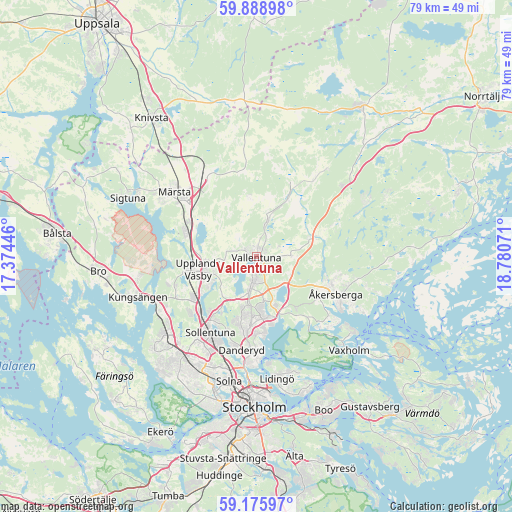
Vallentuna GPS coordinates[2]
59° 32' 3.696" North, 18° 4' 39.288" East
| Map corner | latitude | longitude |
|---|---|---|
| Upper-left | 59.88898°, | 17.37446° |
| Center: | 59.53436°, | 18.07758° |
| Lower-right: | 59.17597°, | 18.78071° |
| Map W x H: | 79.3×79.3 km | = 49.3×49.3mi |
| max Lat: | 67.85572° ⇑32.7% North |
| Vallentuna: | 59.53436° |
| min Lat: | ⇓67.3% South 55.34337° |
| min Long | Vallentuna | max Long |
| 11.1712° | 18.07758° | 24.13676° |
| W 86.9%⇐ | ⇒13.1% E |
Elevation
Elevation of Vallentuna is 20 m = 66 ft, and this is 62.6 m = 205 ft below average elevation for this country.
| Max E: |
663 m = 2175 ft | 75.3% |
| Avg. | 82.6 m = 271 ft | |
| Vallentuna | 20 m = 66 ft | |
Min E: |
-1 m = -3 ft | 24.7% |
See also: Sweden elevation on elevation.city.
Geographical zone
Vallentuna is located in North temperate zone (between Tropic of Cancer and the Arctic Circle). Distance of this North polar circle is 781.6 km =485.7 mi to North.| Distance of | km | miles | from Vallentuna |
|---|---|---|---|
| North Pole | 3387.5 | 2104.9 | to North |
| Arctic Circle | 781.6 | 485.7 | to North |
| Tropic Cancer | 4013.7 | 2494 | to South |
| Equator | 6619.6 | 4113.2 | to South |


Nearby cities:
15 places around Vallentuna: (largest is in red/bold)
• Akalla
16.2 km =10.1 mi,  214°
214°
• Bergshamra
17.2 km =10.7 mi,  188°
188°
• Djursholm
15.1 km =9.4 mi,  184°
184°
• Enebyberg
11.3 km =7 mi, 187°
• Karby
8.6 km =5.3 mi,  69°
69°
• Kista
16.4 km =10.2 mi, 207°
• Lindholmen
5.6 km =3.5 mi,  13°
13°
• Märsta
15.9 km =9.9 mi,  307°
307°
• Rosersberg
12.2 km =7.6 mi,  296°
296°
• Rydbo
10.1 km =6.3 mi,  142°
142°
• Sollentuna
13.8 km =8.6 mi, 211°
• Steninge
17.1 km =10.6 mi, 296°
• Täby
10.1 km =6.3 mi, 182°
• Upplands Väsby
9.5 km =5.9 mi,  259°
259°
• Åkersberga
13.9 km =8.6 mi,  115°
115°
Sources, notices
• [Note1] Compared only with cities in Sweden existing in our database
• [Src1] Map data: © OpenStreetMap contributors (CC-BY-SA)
• [Src2] Other city data from geonames.org with taken over terms of usage.
• [Src3] Geographical zone / Annual Mean Temperature by Robert A. Rohde @ Wikipedia
