Lindholmen geodata
Lindholmen (Stockholm) is a populated place; located in Sweden in Europe/Stockholm (GMT+2) time zone. With population of 1,146 people, there are 761 cities with bigger population in this country. Compared to other cities in Sweden, 67.8% of cities are located further ↓South; 87.2% of cities are located further ←West and 54.7% of cities have higher elevation than Lindholmen. Note1


Lindholmen GPS coordinates[2]
59° 34' 59.988" North, 18° 6' 0" East
| Map corner | latitude | longitude |
|---|---|---|
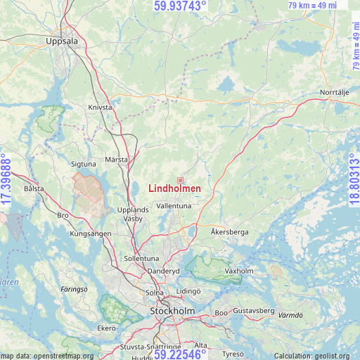
| Upper-left | 59.93743°, | 17.39688° |
| Center: | 59.58333°, | 18.1° |
| Lower-right: | 59.22546°, | 18.80313° |
| Map W x H: | 79.2×79.2 km | = 49.2×49.2mi |
| max Lat: | 67.85572° ⇑32.2% North |
| Lindholmen: | 59.58333° |
| min Lat: | ⇓67.8% South 55.34337° |
| min Long | Lindholmen | max Long |
| 11.1712° | 18.1° | 24.13676° |
| W 87.2%⇐ | ⇒12.8% E |
Elevation
Elevation of Lindholmen is 43 m = 141 ft, and this is 39.6 m = 130 ft below average elevation for this country.
| Max E: |
663 m = 2175 ft | 54.7% |
| Avg. | 82.6 m = 271 ft | |
| Lindholmen | 43 m = 141 ft | |
Min E: |
-1 m = -3 ft | 45.3% |
See also: Sweden elevation on elevation.city.
Geographical zone
Lindholmen is located in North temperate zone (between Tropic of Cancer and the Arctic Circle). Distance of this North polar circle is 776.1 km =482.2 mi to North.| Distance of | km | miles | from Lindholmen |
|---|---|---|---|
| North Pole | 3382 | 2101.5 | to North |
| Arctic Circle | 776.1 | 482.2 | to North |
| Tropic Cancer | 4019.1 | 2497.4 | to South |
| Equator | 6625 | 4116.6 | to South |


Nearby cities:
15 places around Lindholmen: (largest is in red/bold)
• Akalla
21.5 km =13.4 mi,  209°
209°
• Brunna
21.1 km =13.1 mi,  249°
249°
• Djursholm
20.6 km =12.8 mi,  186°
186°
• Enebyberg
16.9 km =10.5 mi, 189°
• Karby
7.2 km =4.5 mi,  110°
110°
• Kårsta
12.7 km =7.9 mi,  50°
50°
• Märsta
14.4 km =8.9 mi,  287°
287°
• Rosersberg
12.2 km =7.6 mi,  270°
270°
• Rydbo
14.3 km =8.9 mi,  160°
160°
• Sollentuna
19.2 km =11.9 mi, 205°
• Steninge
16.8 km =10.4 mi,  277°
277°
• Täby
15.6 km =9.7 mi, 186°
• Upplands Väsby
12.9 km =8 mi,  235°
235°
• Vallentuna
5.6 km =3.5 mi, 193°
• Åkersberga
16.1 km =10 mi,  135°
135°
Sources, notices
• [Note1] Compared only with cities in Sweden existing in our database
• [Src1] Map data: © OpenStreetMap contributors (CC-BY-SA)
• [Src2] Other city data from geonames.org with taken over terms of usage.
• [Src3] Geographical zone / Annual Mean Temperature by Robert A. Rohde @ Wikipedia
