Undersåker geodata
Undersåker (Jämtland) is a populated place; located in Sweden in Europe/Stockholm (GMT+2) time zone. With population of 573 people, there are 1206 cities with bigger population in this country. Compared to other cities in Sweden, 90.3% of cities are located further ↓South; 74.8% of cities are located further →East and 99.7% of cities have lower elevation than Undersåker. Note1


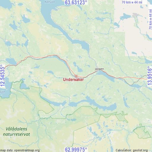
Undersåker GPS coordinates[2]
63° 19' 1.992" North, 13° 14' 54.492" East
| Map corner | latitude | longitude |
|---|---|---|
| Upper-left | 63.63123°, | 12.54535° |
| Center: | 63.31722°, | 13.24847° |
| Lower-right: | 62.99975°, | 13.9516° |
| Map W x H: | 70.2×70.2 km | = 43.6×43.6mi |
| max Lat: | 67.85572° ⇑9.7% North |
| Undersåker: | 63.31722° |
| min Lat: | ⇓90.3% South 55.34337° |
| min Long | Undersåker | max Long |
| 11.1712° | 13.24847° | 24.13676° |
| W 25.2%⇐ | ⇒74.8% E |
Elevation
Elevation of Undersåker is 445 m = 1460 ft, and this is 362.4 m = 1189 ft above average elevation for this country.
| Max E: |
663 m = 2175 ft | 0.3% |
| Undersåker | 445 m 1460 ft | |
| Avg. | 82.6 m = 271 ft | |
Min E: |
-1 m = -3 ft | 99.7% |
See also: Sweden elevation on elevation.city.
Geographical zone
Undersåker is located in North temperate zone (between Tropic of Cancer and the Arctic Circle). Distance of this North polar circle is 361 km =224.3 mi to North.| Distance of | km | miles | from Undersåker |
|---|---|---|---|
| North Pole | 2966.8 | 1843.5 | to North |
| Arctic Circle | 361 | 224.3 | to North |
| Tropic Cancer | 4434.3 | 2755.3 | to South |
| Equator | 7040.2 | 4374.6 | to South |


Nearby cities:
15 places around Undersåker: (largest is in red/bold)
• Björnänge
9.3 km =5.8 mi,  322°
322°
• Duved
21.1 km =13.1 mi,  295°
295°
• Dvärsätt
60.8 km =37.8 mi,  90°
90°
• Föllinge
78.2 km =48.6 mi,  60°
60°
• Hackås
77.8 km =48.3 mi,  124°
124°
• Hoverberg
82.3 km =51.1 mi,  132°
132°
• Järpen
11.3 km =7 mi,  73°
73°
• Krokom
59.9 km =37.2 mi, 89°
• Lit
79.8 km =49.6 mi, 89°
• Mörsil
20.7 km =12.9 mi, 92°
• Nälden
50.1 km =31.1 mi, 85°
• Valla
37.7 km =23.4 mi,  46°
46°
• Åre
12.4 km =7.7 mi, 317°
• Ås
66.3 km =41.2 mi,  96°
96°
• Östersund
71.1 km =44.2 mi, 102°
Sources, notices
• [Note1] Compared only with cities in Sweden existing in our database
• [Src1] Map data: © OpenStreetMap contributors (CC-BY-SA)
• [Src2] Other city data from geonames.org with taken over terms of usage.
• [Src3] Geographical zone / Annual Mean Temperature by Robert A. Rohde @ Wikipedia
