Torup geodata
Torup (Halland) is a populated place; located in Sweden in Europe/Stockholm (GMT+2) time zone. With population of 1,245 people, there are 729 cities with bigger population in this country. Compared to other cities in Sweden, 78.3% of cities are located further ↑North; 78.1% of cities are located further →East and 67.2% of cities have lower elevation than Torup. Note1
Administrative division(s):
- Level 1: Halland
- Level 2: Hylte Kommun
- Level 3: Torup
- Level 4: Torup socken


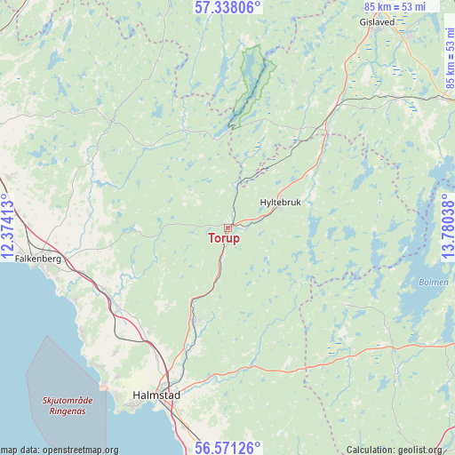
Torup GPS coordinates[2]
56° 57' 23.868" North, 13° 4' 38.1" East
| Map corner | latitude | longitude |
|---|---|---|
| Upper-left | 57.33806°, | 12.37413° |
| Center: | 56.95663°, | 13.07725° |
| Lower-right: | 56.57126°, | 13.78038° |
| Map W x H: | 85.3×85.3 km | = 53×53mi |
| max Lat: | 67.85572° ⇑78.3% North |
| Torup: | 56.95663° |
| min Lat: | ⇓21.7% South 55.34337° |
| min Long | Torup | max Long |
| 11.1712° | 13.07725° | 24.13676° |
| W 21.9%⇐ | ⇒78.1% E |
Elevation
Elevation of Torup is 90 m = 295 ft, and this is 7.4 m = 24 ft above average elevation for this country.
| Max E: |
663 m = 2175 ft | 32.8% |
| Torup | 90 m 295 ft | |
| Avg. | 82.6 m = 271 ft | |
Min E: |
-1 m = -3 ft | 67.2% |
See also: Sweden elevation on elevation.city.
Geographical zone
Torup is located in North temperate zone (between Tropic of Cancer and the Arctic Circle). Distance of this North polar circle is 1068.2 km =663.7 mi to North.| Distance of | km | miles | from Torup |
|---|---|---|---|
| North Pole | 3674.1 | 2283 | to North |
| Arctic Circle | 1068.2 | 663.7 | to North |
| Tropic Cancer | 3727.1 | 2315.9 | to South |
| Equator | 6333 | 3935.1 | to South |


Nearby cities:
15 places around Torup: (largest is in red/bold)
• Burseryd
29.8 km =18.5 mi,  24°
24°
• Getinge
26 km =16.2 mi,  233°
233°
• Harplinge
31.7 km =19.7 mi,  222°
222°
• Holm
27.7 km =17.2 mi,  209°
209°
• Hyltebruk
10.9 km =6.8 mi,  64°
64°
• Kvibille
24.3 km =15.1 mi, 217°
• Lidhult
25.6 km =15.9 mi,  122°
122°
• Oskarström
18.7 km =11.6 mi,  201°
201°
• Simlångsdalen
26.3 km =16.3 mi,  172°
172°
• Slöinge
26.7 km =16.6 mi,  243°
243°
• Smålandsstenar
30.6 km =19 mi,  41°
41°
• Ullared
29.4 km =18.3 mi,  312°
312°
• Unnaryd
26.7 km =16.6 mi,  91°
91°
• Vessigebro
26.1 km =16.2 mi,  276°
276°
• Åled
24.6 km =15.3 mi, 200°
Sources, notices
• [Note1] Compared only with cities in Sweden existing in our database
• [Src1] Map data: © OpenStreetMap contributors (CC-BY-SA)
• [Src2] Other city data from geonames.org with taken over terms of usage.
• [Src3] Geographical zone / Annual Mean Temperature by Robert A. Rohde @ Wikipedia
