Unnaryd geodata
Unnaryd (Halland) is a populated place; located in Sweden in Europe/Stockholm (GMT+2) time zone. With population of 823 people, there are 946 cities with bigger population in this country. Compared to other cities in Sweden, 78.5% of cities are located further ↑North; 70.9% of cities are located further →East and 86.7% of cities have lower elevation than Unnaryd. Note1


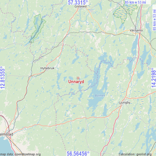
Unnaryd GPS coordinates[2]
56° 57' 0" North, 13° 31' 0.012" East
| Map corner | latitude | longitude |
|---|---|---|
| Upper-left | 57.3315°, | 12.81355° |
| Center: | 56.95°, | 13.51667° |
| Lower-right: | 56.56456°, | 14.2198° |
| Map W x H: | 85.3×85.3 km | = 53×53mi |
| max Lat: | 67.85572° ⇑78.5% North |
| Unnaryd: | 56.95° |
| min Lat: | ⇓21.5% South 55.34337° |
| min Long | Unnaryd | max Long |
| 11.1712° | 13.51667° | 24.13676° |
| W 29.1%⇐ | ⇒70.9% E |
Elevation
Elevation of Unnaryd is 176 m = 577 ft, and this is 93.4 m = 306 ft above average elevation for this country.
| Max E: |
663 m = 2175 ft | 13.3% |
| Unnaryd | 176 m 577 ft | |
| Avg. | 82.6 m = 271 ft | |
Min E: |
-1 m = -3 ft | 86.7% |
See also: Sweden elevation on elevation.city.
Geographical zone
Unnaryd is located in North temperate zone (between Tropic of Cancer and the Arctic Circle). Distance of this North polar circle is 1068.9 km =664.2 mi to North.| Distance of | km | miles | from Unnaryd |
|---|---|---|---|
| North Pole | 3674.8 | 2283.4 | to North |
| Arctic Circle | 1068.9 | 664.2 | to North |
| Tropic Cancer | 3726.3 | 2315.4 | to South |
| Equator | 6332.2 | 3934.6 | to South |


Nearby cities:
15 places around Unnaryd: (largest is in red/bold)
• Anderstorp
37.7 km =23.4 mi,  10°
10°
• Bredaryd
28.2 km =17.5 mi,  28°
28°
• Burseryd
31.2 km =19.4 mi,  333°
333°
• Forsheda
30.4 km =18.9 mi,  38°
38°
• Gislaved
39.4 km =24.5 mi,  2°
2°
• Hyltebruk
17.7 km =11 mi,  287°
287°
• Lagan
28.6 km =17.8 mi,  97°
97°
• Lidhult
13.9 km =8.6 mi,  201°
201°
• Ljungby
28.8 km =17.9 mi,  116°
116°
• Oskarström
37.3 km =23.2 mi,  243°
243°
• Reftele
25.4 km =15.8 mi, 10°
• Ryssby
40.5 km =25.2 mi, 103°
• Simlångsdalen
34.5 km =21.4 mi,  222°
222°
• Smålandsstenar
24.4 km =15.2 mi,  345°
345°
• Torup
26.7 km =16.6 mi,  271°
271°
Sources, notices
• [Note1] Compared only with cities in Sweden existing in our database
• [Src1] Map data: © OpenStreetMap contributors (CC-BY-SA)
• [Src2] Other city data from geonames.org with taken over terms of usage.
• [Src3] Geographical zone / Annual Mean Temperature by Robert A. Rohde @ Wikipedia
