Lidhult geodata
Lidhult (Kronoberg) is a populated place; located in Sweden in Europe/Stockholm (GMT+2) time zone. With population of 665 people, there are 1103 cities with bigger population in this country. Compared to other cities in Sweden, 79.5% of cities are located further ↑North; 72.5% of cities are located further →East and 83.8% of cities have lower elevation than Lidhult. Note1


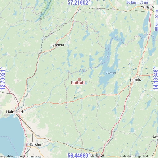
Lidhult GPS coordinates[2]
56° 49' 59.988" North, 13° 25' 59.988" East
| Map corner | latitude | longitude |
|---|---|---|
| Upper-left | 57.21602°, | 12.73021° |
| Center: | 56.83333°, | 13.43333° |
| Lower-right: | 56.44669°, | 14.13646° |
| Map W x H: | 85.5×85.5 km | = 53.1×53.1mi |
| max Lat: | 67.85572° ⇑79.5% North |
| Lidhult: | 56.83333° |
| min Lat: | ⇓20.5% South 55.34337° |
| min Long | Lidhult | max Long |
| 11.1712° | 13.43333° | 24.13676° |
| W 27.5%⇐ | ⇒72.5% E |
Elevation
Elevation of Lidhult is 163 m = 535 ft, and this is 80.4 m = 264 ft above average elevation for this country.
| Max E: |
663 m = 2175 ft | 16.2% |
| Lidhult | 163 m 535 ft | |
| Avg. | 82.6 m = 271 ft | |
Min E: |
-1 m = -3 ft | 83.8% |
See also: Sweden elevation on elevation.city.
Geographical zone
Lidhult is located in North temperate zone (between Tropic of Cancer and the Arctic Circle). Distance of this North polar circle is 1081.9 km =672.3 mi to North.| Distance of | km | miles | from Lidhult |
|---|---|---|---|
| North Pole | 3687.8 | 2291.5 | to North |
| Arctic Circle | 1081.9 | 672.3 | to North |
| Tropic Cancer | 3713.4 | 2307.4 | to South |
| Equator | 6319.3 | 3926.6 | to South |


Nearby cities:
15 places around Lidhult: (largest is in red/bold)
• Holm
36.8 km =22.9 mi,  253°
253°
• Hyltebruk
21.8 km =13.5 mi,  327°
327°
• Knäred
35.6 km =22.1 mi,  190°
190°
• Kvibille
36.9 km =22.9 mi,  261°
261°
• Kyrkhult
33.1 km =20.6 mi,  197°
197°
• Lagan
34.7 km =21.6 mi,  74°
74°
• Ljungby
30.9 km =19.2 mi,  90°
90°
• Oskarström
28.6 km =17.8 mi, 262°
• Simlångsdalen
22.1 km =13.7 mi,  235°
235°
• Smålandsstenar
36.6 km =22.7 mi,  357°
357°
• Strömsnäsbruk
35.9 km =22.3 mi,  151°
151°
• Torup
25.6 km =15.9 mi,  302°
302°
• Traryd
34.3 km =21.3 mi, 145°
• Unnaryd
13.9 km =8.6 mi,  21°
21°
• Åled
31.8 km =19.8 mi, 253°
Sources, notices
• [Note1] Compared only with cities in Sweden existing in our database
• [Src1] Map data: © OpenStreetMap contributors (CC-BY-SA)
• [Src2] Other city data from geonames.org with taken over terms of usage.
• [Src3] Geographical zone / Annual Mean Temperature by Robert A. Rohde @ Wikipedia
