Sunningen geodata
Sunningen (Västra Götaland) is a populated place; located in Sweden in Europe/Stockholm (GMT+2) time zone. With population of 589 people, there are 1187 cities with bigger population in this country. Compared to other cities in Sweden, 56.1% of cities are located further ↑North; 96.5% of cities are located further →East and 57.9% of cities have lower elevation than Sunningen. Note1


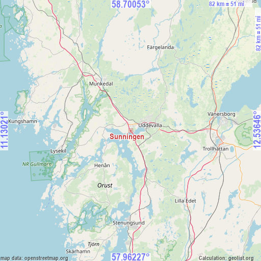
Sunningen GPS coordinates[2]
58° 19' 59.988" North, 11° 49' 59.988" East
| Map corner | latitude | longitude |
|---|---|---|
| Upper-left | 58.70053°, | 11.13021° |
| Center: | 58.33333°, | 11.83333° |
| Lower-right: | 57.96227°, | 12.53646° |
| Map W x H: | 82.1×82.1 km | = 51×51mi |
| max Lat: | 67.85572° ⇑56.1% North |
| Sunningen: | 58.33333° |
| min Lat: | ⇓43.9% South 55.34337° |
| min Long | Sunningen | max Long |
| 11.1712° | 11.83333° | 24.13676° |
| W 3.5%⇐ | ⇒96.5% E |
Elevation
Elevation of Sunningen is 65 m = 213 ft, and this is 17.6 m = 58 ft below average elevation for this country.
| Max E: |
663 m = 2175 ft | 42.1% |
| Avg. | 82.6 m = 271 ft | |
| Sunningen | 65 m = 213 ft | |
Min E: |
-1 m = -3 ft | 57.9% |
See also: Sweden elevation on elevation.city.
Geographical zone
Sunningen is located in North temperate zone (between Tropic of Cancer and the Arctic Circle). Distance of this North polar circle is 915.1 km =568.6 mi to North.| Distance of | km | miles | from Sunningen |
|---|---|---|---|
| North Pole | 3521 | 2187.8 | to North |
| Arctic Circle | 915.1 | 568.6 | to North |
| Tropic Cancer | 3880.1 | 2411 | to South |
| Equator | 6486.1 | 4030.3 | to South |


Nearby cities:
15 places around Sunningen: (largest is in red/bold)
• Ammenäs
2.2 km =1.4 mi,  189°
189°
• Brastad
21.2 km =13.2 mi,  285°
285°
• Dingle
26.2 km =16.3 mi,  325°
325°
• Ellös
27.2 km =16.9 mi,  232°
232°
• Henån
14 km =8.7 mi,  221°
221°
• Ljungskile
13.1 km =8.1 mi,  157°
157°
• Lysekil
24.1 km =15 mi,  254°
254°
• Munkedal
17.5 km =10.9 mi, 327°
• Sjuntorp
26.9 km =16.7 mi,  123°
123°
• Svanesund
21.2 km =13.2 mi,  182°
182°
• Trollhättan
27.2 km =16.9 mi,  101°
101°
• Uddevalla
6.6 km =4.1 mi,  75°
75°
• Varekil
24.5 km =15.2 mi,  197°
197°
• Ödeborg
24.9 km =15.5 mi,  19°
19°
• Ödsmål
26 km =16.2 mi, 177°
Sources, notices
• [Note1] Compared only with cities in Sweden existing in our database
• [Src1] Map data: © OpenStreetMap contributors (CC-BY-SA)
• [Src2] Other city data from geonames.org with taken over terms of usage.
• [Src3] Geographical zone / Annual Mean Temperature by Robert A. Rohde @ Wikipedia
