Uddevalla geodata
Uddevalla (Västra Götaland) is a seat of a second-order administrative division; located in Sweden in Europe/Stockholm (GMT+2) time zone. With population of 34,781 people, there are 44 cities with bigger population in this country. Compared to other cities in Sweden, 55.9% of cities are located further ↑North; 95.3% of cities are located further →East and 84.8% of cities have higher elevation than Uddevalla. Note1


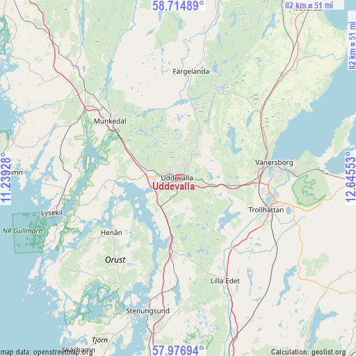
Uddevalla GPS coordinates[2]
58° 20' 52.224" North, 11° 56' 32.64" East
| Map corner | latitude | longitude |
|---|---|---|
| Upper-left | 58.71489°, | 11.23928° |
| Center: | 58.34784°, | 11.9424° |
| Lower-right: | 57.97694°, | 12.64553° |
| Map W x H: | 82.1×82.1 km | = 51×51mi |
| max Lat: | 67.85572° ⇑55.9% North |
| Uddevalla: | 58.34784° |
| min Lat: | ⇓44.1% South 55.34337° |
| min Long | Uddevalla | max Long |
| 11.1712° | 11.9424° | 24.13676° |
| W 4.7%⇐ | ⇒95.3% E |
Elevation
Elevation of Uddevalla is 13 m = 43 ft, and this is 69.6 m = 228 ft below average elevation for this country.
| Max E: |
663 m = 2175 ft | 84.8% |
| Avg. | 82.6 m = 271 ft | |
| Uddevalla | 13 m = 43 ft | |
Min E: |
-1 m = -3 ft | 15.2% |
See also: Sweden elevation on elevation.city.
Geographical zone
Uddevalla is located in North temperate zone (between Tropic of Cancer and the Arctic Circle). Distance of this North polar circle is 913.5 km =567.6 mi to North.| Distance of | km | miles | from Uddevalla |
|---|---|---|---|
| North Pole | 3519.4 | 2186.9 | to North |
| Arctic Circle | 913.5 | 567.6 | to North |
| Tropic Cancer | 3881.8 | 2412 | to South |
| Equator | 6487.7 | 4031.3 | to South |


Nearby cities:
15 places around Uddevalla: (largest is in red/bold)
• Ammenäs
7.7 km =4.8 mi,  240°
240°
• Frändefors
26.1 km =16.2 mi,  49°
49°
• Färgelanda
24.7 km =15.3 mi,  6°
6°
• Henån
19.8 km =12.3 mi,  232°
232°
• Lilla Edet
26.3 km =16.3 mi,  154°
154°
• Ljungskile
13.8 km =8.6 mi,  185°
185°
• Munkedal
20.5 km =12.7 mi,  310°
310°
• Sjuntorp
23 km =14.3 mi,  135°
135°
• Sunningen
6.6 km =4.1 mi,  255°
255°
• Svanesund
23.9 km =14.9 mi,  197°
197°
• Trollhättan
21.4 km =13.3 mi,  109°
109°
• Vargön
26.2 km =16.3 mi,  88°
88°
• Velanda
25.2 km =15.7 mi,  121°
121°
• Vänersborg
22.5 km =14 mi,  80°
80°
• Ödeborg
22 km =13.7 mi,  4°
4°
Sources, notices
• [Note1] Compared only with cities in Sweden existing in our database
• [Src1] Map data: © OpenStreetMap contributors (CC-BY-SA)
• [Src2] Other city data from geonames.org with taken over terms of usage.
• [Src3] Geographical zone / Annual Mean Temperature by Robert A. Rohde @ Wikipedia
