Lysekil geodata
Lysekil (Västra Götaland) is a seat of a second-order administrative division; located in Sweden in Europe/Stockholm (GMT+2) time zone. With population of 7,734 people, there are 190 cities with bigger population in this country. Compared to other cities in Sweden, 56.8% of cities are located further ↑North; 99.2% of cities are located further →East and 85.7% of cities have higher elevation than Lysekil. Note1


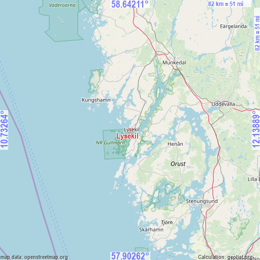
Lysekil GPS coordinates[2]
58° 16' 27.444" North, 11° 26' 8.736" East
| Map corner | latitude | longitude |
|---|---|---|
| Upper-left | 58.64211°, | 10.73264° |
| Center: | 58.27429°, | 11.43576° |
| Lower-right: | 57.90262°, | 12.13889° |
| Map W x H: | 82.2×82.2 km | = 51.1×51.1mi |
| max Lat: | 67.85572° ⇑56.8% North |
| Lysekil: | 58.27429° |
| min Lat: | ⇓43.2% South 55.34337° |
| min Long | Lysekil | max Long |
| 11.1712° | 11.43576° | 24.13676° |
| W 0.8%⇐ | ⇒99.2% E |
Elevation
Elevation of Lysekil is 12 m = 39 ft, and this is 70.6 m = 232 ft below average elevation for this country.
| Max E: |
663 m = 2175 ft | 85.7% |
| Avg. | 82.6 m = 271 ft | |
| Lysekil | 12 m = 39 ft | |
Min E: |
-1 m = -3 ft | 14.3% |
See also: Sweden elevation on elevation.city.
Geographical zone
Lysekil is located in North temperate zone (between Tropic of Cancer and the Arctic Circle). Distance of this North polar circle is 921.7 km =572.7 mi to North.| Distance of | km | miles | from Lysekil |
|---|---|---|---|
| North Pole | 3527.6 | 2191.9 | to North |
| Arctic Circle | 921.7 | 572.7 | to North |
| Tropic Cancer | 3873.6 | 2406.9 | to South |
| Equator | 6479.5 | 4026.2 | to South |


Nearby cities:
15 places around Lysekil: (largest is in red/bold)
• Ammenäs
23.3 km =14.5 mi,  79°
79°
• Brastad
12.4 km =7.7 mi,  12°
12°
• Ellös
10.3 km =6.4 mi,  169°
169°
• Grundsund
7 km =4.3 mi,  188°
188°
• Henån
14.6 km =9.1 mi,  105°
105°
• Hunnebostrand
20.1 km =12.5 mi,  337°
337°
• Klövedal
28.2 km =17.5 mi,  162°
162°
• Kungshamn
14.3 km =8.9 mi,  313°
313°
• Ljungskile
28.9 km =18 mi,  101°
101°
• Munkedal
25.5 km =15.8 mi,  32°
32°
• Smögen
15.3 km =9.5 mi, 306°
• Sunningen
24.1 km =15 mi,  74°
74°
• Svanesund
26.7 km =16.6 mi,  123°
123°
• Varekil
23.2 km =14.4 mi,  136°
136°
• Väjern
15.6 km =9.7 mi,  320°
320°
Sources, notices
• [Note1] Compared only with cities in Sweden existing in our database
• [Src1] Map data: © OpenStreetMap contributors (CC-BY-SA)
• [Src2] Other city data from geonames.org with taken over terms of usage.
• [Src3] Geographical zone / Annual Mean Temperature by Robert A. Rohde @ Wikipedia
