Ljungskile geodata
Ljungskile (Västra Götaland) is a populated place; located in Sweden in Europe/Stockholm (GMT+2) time zone. With population of 3,689 people, there are 350 cities with bigger population in this country. Compared to other cities in Sweden, 57.6% of cities are located further ↑North; 95.7% of cities are located further →East and 96.4% of cities have higher elevation than Ljungskile. Note1
Administrative division(s):
- Level 1: Västra Götaland
- Level 2: Uddevalla Kommun
- Level 3: Ljung
- Level 4: Ljung socken


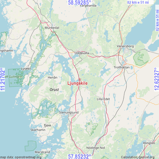
Ljungskile GPS coordinates[2]
58° 13' 28.272" North, 11° 55' 12.504" East
| Map corner | latitude | longitude |
|---|---|---|
| Upper-left | 58.59285°, | 11.21702° |
| Center: | 58.22452°, | 11.92014° |
| Lower-right: | 57.85232°, | 12.62327° |
| Map W x H: | 82.3×82.3 km | = 51.1×51.1mi |
| max Lat: | 67.85572° ⇑57.6% North |
| Ljungskile: | 58.22452° |
| min Lat: | ⇓42.4% South 55.34337° |
| min Long | Ljungskile | max Long |
| 11.1712° | 11.92014° | 24.13676° |
| W 4.3%⇐ | ⇒95.7% E |
Elevation
Elevation of Ljungskile is 4 m = 13 ft, and this is 78.6 m = 258 ft below average elevation for this country.
| Max E: |
663 m = 2175 ft | 96.4% |
| Avg. | 82.6 m = 271 ft | |
| Ljungskile | 4 m = 13 ft | |
Min E: |
-1 m = -3 ft | 3.6% |
See also: Sweden elevation on elevation.city.
Geographical zone
Ljungskile is located in North temperate zone (between Tropic of Cancer and the Arctic Circle). Distance of this North polar circle is 927.2 km =576.1 mi to North.| Distance of | km | miles | from Ljungskile |
|---|---|---|---|
| North Pole | 3533.1 | 2195.4 | to North |
| Arctic Circle | 927.2 | 576.1 | to North |
| Tropic Cancer | 3868 | 2403.5 | to South |
| Equator | 6474 | 4022.8 | to South |


Nearby cities:
15 places around Ljungskile: (largest is in red/bold)
• Ammenäs
11.3 km =7 mi,  331°
331°
• Göta
18.9 km =11.7 mi,  133°
133°
• Henån
14.4 km =8.9 mi,  276°
276°
• Lilla Edet
16.1 km =10 mi, 129°
• Myggenäs
20.7 km =12.9 mi,  208°
208°
• Sjuntorp
17.6 km =10.9 mi,  98°
98°
• Stenungsund
18.1 km =11.2 mi,  199°
199°
• Sunningen
13.1 km =8.1 mi,  337°
337°
• Svanesund
10.9 km =6.8 mi, 213°
• Trollhättan
22.5 km =14 mi,  73°
73°
• Ucklum
15.8 km =9.8 mi,  173°
173°
• Uddevalla
13.8 km =8.6 mi,  5°
5°
• Varekil
16.8 km =10.4 mi,  227°
227°
• Velanda
22.8 km =14.2 mi,  88°
88°
• Ödsmål
14.4 km =8.9 mi, 196°
Sources, notices
• [Note1] Compared only with cities in Sweden existing in our database
• [Src1] Map data: © OpenStreetMap contributors (CC-BY-SA)
• [Src2] Other city data from geonames.org with taken over terms of usage.
• [Src3] Geographical zone / Annual Mean Temperature by Robert A. Rohde @ Wikipedia
