Strömsund geodata
Strömsund (Jämtland) is a seat of a second-order administrative division; located in Sweden in Europe/Stockholm (GMT+2) time zone. With population of 3,690 people, there are 349 cities with bigger population in this country. Compared to other cities in Sweden, 92.7% of cities are located further ↓South; 56.2% of cities are located further ←West and 96% of cities have lower elevation than Strömsund. Note1


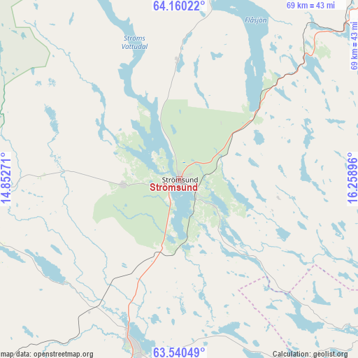
Strömsund GPS coordinates[2]
63° 51' 7.416" North, 15° 33' 20.988" East
| Map corner | latitude | longitude |
|---|---|---|
| Upper-left | 64.16022°, | 14.85271° |
| Center: | 63.85206°, | 15.55583° |
| Lower-right: | 63.54049°, | 16.25896° |
| Map W x H: | 68.9×68.9 km | = 42.8×42.8mi |
| max Lat: | 67.85572° ⇑7.3% North |
| Strömsund: | 63.85206° |
| min Lat: | ⇓92.7% South 55.34337° |
| min Long | Strömsund | max Long |
| 11.1712° | 15.55583° | 24.13676° |
| W 56.2%⇐ | ⇒43.8% E |
Elevation
Elevation of Strömsund is 299 m = 981 ft, and this is 216.4 m = 710 ft above average elevation for this country.
| Max E: |
663 m = 2175 ft | 4% |
| Strömsund | 299 m 981 ft | |
| Avg. | 82.6 m = 271 ft | |
Min E: |
-1 m = -3 ft | 96% |
See also: Sweden elevation on elevation.city.
Geographical zone
Strömsund is located in North temperate zone (between Tropic of Cancer and the Arctic Circle). Distance of this North polar circle is 301.5 km =187.3 mi to North.| Distance of | km | miles | from Strömsund |
|---|---|---|---|
| North Pole | 2907.4 | 1806.6 | to North |
| Arctic Circle | 301.5 | 187.3 | to North |
| Tropic Cancer | 4493.8 | 2792.3 | to South |
| Equator | 7099.7 | 4411.5 | to South |


Nearby cities:
15 places around Strömsund: (largest is in red/bold)
• Backe
41.6 km =25.8 mi,  95°
95°
• Dorotea
61.8 km =38.4 mi,  42°
42°
• Dvärsätt
80.3 km =49.9 mi,  222°
222°
• Föllinge
50.6 km =31.4 mi,  245°
245°
• Hammerdal
32.1 km =19.9 mi,  197°
197°
• Hoting
43 km =26.7 mi,  47°
47°
• Junsele
67.5 km =41.9 mi, 104°
• Krokom
80.1 km =49.8 mi, 223°
• Lit
68.8 km =42.8 mi,  210°
210°
• Näsåker
80.5 km =50 mi,  124°
124°
• Ramsele
56.8 km =35.3 mi,  127°
127°
• Stugun
76.2 km =47.3 mi,  178°
178°
• Sörvik
32.2 km =20 mi,  14°
14°
• Ås
74.1 km =46 mi,  136°
136°
• Ås
83 km =51.6 mi, 216°
Sources, notices
• [Note1] Compared only with cities in Sweden existing in our database
• [Src1] Map data: © OpenStreetMap contributors (CC-BY-SA)
• [Src2] Other city data from geonames.org with taken over terms of usage.
• [Src3] Geographical zone / Annual Mean Temperature by Robert A. Rohde @ Wikipedia
