Strömma geodata
Strömma (Stockholm) is a populated place; located in Sweden in Europe/Stockholm (GMT+2) time zone. With population of 2,468 people, there are 458 cities with bigger population in this country. Compared to other cities in Sweden, 59.3% of cities are located further ↓South; 91.1% of cities are located further ←West and 75.3% of cities have higher elevation than Strömma. Note1
Administrative division(s):
- Level 1: Stockholm
- Level 2: Värmdö Kommun
- Level 3: Värmdö
- Level 4: Värmdö socken


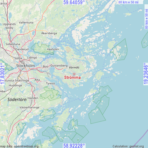
Strömma GPS coordinates[2]
59° 16' 59.988" North, 18° 31' 59.988" East
| Map corner | latitude | longitude |
|---|---|---|
| Upper-left | 59.64059°, | 17.83021° |
| Center: | 59.28333°, | 18.53333° |
| Lower-right: | 58.92228°, | 19.23646° |
| Map W x H: | 79.9×79.9 km | = 49.6×49.6mi |
| max Lat: | 67.85572° ⇑40.7% North |
| Strömma: | 59.28333° |
| min Lat: | ⇓59.3% South 55.34337° |
| min Long | Strömma | max Long |
| 11.1712° | 18.53333° | 24.13676° |
| W 91.1%⇐ | ⇒8.9% E |
Elevation
Elevation of Strömma is 20 m = 66 ft, and this is 62.6 m = 205 ft below average elevation for this country.
| Max E: |
663 m = 2175 ft | 75.3% |
| Avg. | 82.6 m = 271 ft | |
| Strömma | 20 m = 66 ft | |
Min E: |
-1 m = -3 ft | 24.7% |
See also: Sweden elevation on elevation.city.
Geographical zone
Strömma is located in North temperate zone (between Tropic of Cancer and the Arctic Circle). Distance of this North polar circle is 809.5 km =503 mi to North.| Distance of | km | miles | from Strömma |
|---|---|---|---|
| North Pole | 3415.4 | 2122.2 | to North |
| Arctic Circle | 809.5 | 503 | to North |
| Tropic Cancer | 3985.8 | 2476.7 | to South |
| Equator | 6591.7 | 4095.9 | to South |


Nearby cities:
15 places around Strömma: (largest is in red/bold)
• Boo
15.2 km =9.4 mi,  291°
291°
• Brevik
11.3 km =7 mi,  229°
229°
• Brunn
5.9 km =3.7 mi,  266°
266°
• Djurö
11.2 km =7 mi,  64°
64°
• Gustavsberg
9.5 km =5.9 mi,  300°
300°
• Hemmesta
5.1 km =3.2 mi,  328°
328°
• Hölö
7.6 km =4.7 mi,  90°
90°
• Kopparmora
6.2 km =3.9 mi,  27°
27°
• Långvik
4.3 km =2.7 mi,  192°
192°
• Mörtnäs
6.5 km =4 mi,  307°
307°
• Oskar-Fredriksborg
14.2 km =8.8 mi,  336°
336°
• Raksta
15 km =9.3 mi,  242°
242°
• Rindö
14.9 km =9.3 mi, 328°
• Saltsjöbaden
13.3 km =8.3 mi, 270°
• Stavsnäs
8.5 km =5.3 mi, 90°
Sources, notices
• [Note1] Compared only with cities in Sweden existing in our database
• [Src1] Map data: © OpenStreetMap contributors (CC-BY-SA)
• [Src2] Other city data from geonames.org with taken over terms of usage.
• [Src3] Geographical zone / Annual Mean Temperature by Robert A. Rohde @ Wikipedia
