Långvik geodata
Långvik (Stockholm) is a populated place; located in Sweden in Europe/Stockholm (GMT+2) time zone. With population of 1,206 people, there are 738 cities with bigger population in this country. Compared to other cities in Sweden, 58.1% of cities are located further ↓South; 91% of cities are located further ←West and 58.3% of cities have higher elevation than Långvik. Note1


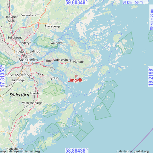
Långvik GPS coordinates[2]
59° 14' 44.988" North, 18° 31' 0.012" East
| Map corner | latitude | longitude |
|---|---|---|
| Upper-left | 59.60349°, | 17.81355° |
| Center: | 59.24583°, | 18.51667° |
| Lower-right: | 58.88438°, | 19.2198° |
| Map W x H: | 80×80 km | = 49.7×49.7mi |
| max Lat: | 67.85572° ⇑41.9% North |
| Långvik: | 59.24583° |
| min Lat: | ⇓58.1% South 55.34337° |
| min Long | Långvik | max Long |
| 11.1712° | 18.51667° | 24.13676° |
| W 91%⇐ | ⇒9% E |
Elevation
Elevation of Långvik is 38 m = 125 ft, and this is 44.6 m = 146 ft below average elevation for this country.
| Max E: |
663 m = 2175 ft | 58.3% |
| Avg. | 82.6 m = 271 ft | |
| Långvik | 38 m = 125 ft | |
Min E: |
-1 m = -3 ft | 41.7% |
See also: Sweden elevation on elevation.city.
Geographical zone
Långvik is located in North temperate zone (between Tropic of Cancer and the Arctic Circle). Distance of this North polar circle is 813.7 km =505.6 mi to North.| Distance of | km | miles | from Långvik |
|---|---|---|---|
| North Pole | 3419.5 | 2124.8 | to North |
| Arctic Circle | 813.7 | 505.6 | to North |
| Tropic Cancer | 3981.6 | 2474.1 | to South |
| Equator | 6587.5 | 4093.3 | to South |


Nearby cities:
15 places around Långvik: (largest is in red/bold)
• Bollmora
16.4 km =10.2 mi,  268°
268°
• Brevik
8.2 km =5.1 mi,  246°
246°
• Brunn
6.2 km =3.9 mi,  307°
307°
• Dalarö
14 km =8.7 mi,  206°
206°
• Djurö
14.2 km =8.8 mi,  50°
50°
• Fisksätra
15.7 km =9.8 mi,  288°
288°
• Gustavsberg
11.5 km =7.1 mi,  321°
321°
• Hemmesta
8.7 km =5.4 mi,  348°
348°
• Hölö
9.5 km =5.9 mi,  63°
63°
• Kopparmora
10.4 km =6.5 mi,  21°
21°
• Mörtnäs
9.1 km =5.7 mi,  332°
332°
• Raksta
12.7 km =7.9 mi,  257°
257°
• Saltsjöbaden
13 km =8.1 mi, 288°
• Stavsnäs
10.3 km =6.4 mi,  66°
66°
• Strömma
4.3 km =2.7 mi,  12°
12°
Sources, notices
• [Note1] Compared only with cities in Sweden existing in our database
• [Src1] Map data: © OpenStreetMap contributors (CC-BY-SA)
• [Src2] Other city data from geonames.org with taken over terms of usage.
• [Src3] Geographical zone / Annual Mean Temperature by Robert A. Rohde @ Wikipedia
