Stora Höga geodata
Stora Höga (Västra Götaland) is a populated place; located in Sweden in Europe/Stockholm (GMT+2) time zone. With population of 2,846 people, there are 419 cities with bigger population in this country. Compared to other cities in Sweden, 60.4% of cities are located further ↑North; 96.5% of cities are located further →East and 87.5% of cities have higher elevation than Stora Höga. Note1


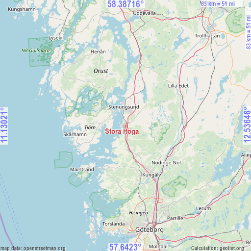
Stora Höga GPS coordinates[2]
58° 1' 0.012" North, 11° 49' 59.988" East
| Map corner | latitude | longitude |
|---|---|---|
| Upper-left | 58.38716°, | 11.13021° |
| Center: | 58.01667°, | 11.83333° |
| Lower-right: | 57.6423°, | 12.53646° |
| Map W x H: | 82.8×82.8 km | = 51.4×51.4mi |
| max Lat: | 67.85572° ⇑60.4% North |
| Stora Höga: | 58.01667° |
| min Lat: | ⇓39.6% South 55.34337° |
| min Long | Stora Höga | max Long |
| 11.1712° | 11.83333° | 24.13676° |
| W 3.5%⇐ | ⇒96.5% E |
Elevation
Elevation of Stora Höga is 11 m = 36 ft, and this is 71.6 m = 235 ft below average elevation for this country.
| Max E: |
663 m = 2175 ft | 87.5% |
| Avg. | 82.6 m = 271 ft | |
| Stora Höga | 11 m = 36 ft | |
Min E: |
-1 m = -3 ft | 12.5% |
See also: Sweden elevation on elevation.city.
Geographical zone
Stora Höga is located in North temperate zone (between Tropic of Cancer and the Arctic Circle). Distance of this North polar circle is 950.3 km =590.5 mi to North.| Distance of | km | miles | from Stora Höga |
|---|---|---|---|
| North Pole | 3556.2 | 2209.7 | to North |
| Arctic Circle | 950.3 | 590.5 | to North |
| Tropic Cancer | 3844.9 | 2389.1 | to South |
| Equator | 6450.8 | 4008.3 | to South |


Nearby cities:
15 places around Stora Höga: (largest is in red/bold)
• Aröd
6.1 km =3.8 mi,  208°
208°
• Diseröd
15.2 km =9.4 mi,  131°
131°
• Höviksnäs
4.3 km =2.7 mi,  295°
295°
• Jörlanda
3.4 km =2.1 mi,  183°
183°
• Klövedal
14.8 km =9.2 mi,  277°
277°
• Kode
8.3 km =5.2 mi,  172°
172°
• Myggenäs
7 km =4.3 mi,  315°
315°
• Skärhamn
16.6 km =10.3 mi,  258°
258°
• Stenungsund
6 km =3.7 mi,  351°
351°
• Svanesund
14.1 km =8.8 mi,  356°
356°
• Tjuvkil
14.3 km =8.9 mi,  204°
204°
• Tollered
17.4 km =10.8 mi,  115°
115°
• Ucklum
10.1 km =6.3 mi,  42°
42°
• Varekil
13.9 km =8.6 mi,  327°
327°
• Ödsmål
9.3 km =5.8 mi,  6°
6°
Sources, notices
• [Note1] Compared only with cities in Sweden existing in our database
• [Src1] Map data: © OpenStreetMap contributors (CC-BY-SA)
• [Src2] Other city data from geonames.org with taken over terms of usage.
• [Src3] Geographical zone / Annual Mean Temperature by Robert A. Rohde @ Wikipedia
