Diseröd geodata
Diseröd (Västra Götaland) is a populated place; located in Sweden in Europe/Stockholm (GMT+2) time zone. With population of 1,328 people, there are 700 cities with bigger population in this country. Compared to other cities in Sweden, 61.9% of cities are located further ↑North; 94.5% of cities are located further →East and 57% of cities have lower elevation than Diseröd. Note1


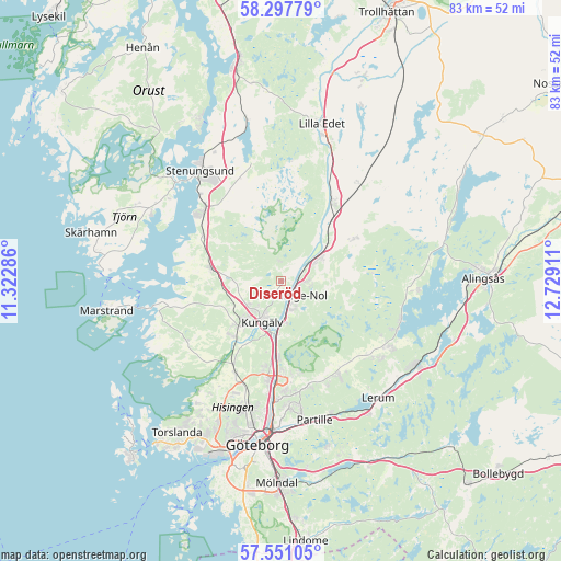
Diseröd GPS coordinates[2]
57° 55' 34.896" North, 12° 1' 33.528" East
| Map corner | latitude | longitude |
|---|---|---|
| Upper-left | 58.29779°, | 11.32286° |
| Center: | 57.92636°, | 12.02598° |
| Lower-right: | 57.55105°, | 12.72911° |
| Map W x H: | 83×83 km | = 51.6×51.6mi |
| max Lat: | 67.85572° ⇑61.9% North |
| Diseröd: | 57.92636° |
| min Lat: | ⇓38.1% South 55.34337° |
| min Long | Diseröd | max Long |
| 11.1712° | 12.02598° | 24.13676° |
| W 5.5%⇐ | ⇒94.5% E |
Elevation
Elevation of Diseröd is 63 m = 207 ft, and this is 19.6 m = 64 ft below average elevation for this country.
| Max E: |
663 m = 2175 ft | 43% |
| Avg. | 82.6 m = 271 ft | |
| Diseröd | 63 m = 207 ft | |
Min E: |
-1 m = -3 ft | 57% |
See also: Sweden elevation on elevation.city.
Geographical zone
Diseröd is located in North temperate zone (between Tropic of Cancer and the Arctic Circle). Distance of this North polar circle is 960.4 km =596.8 mi to North.| Distance of | km | miles | from Diseröd |
|---|---|---|---|
| North Pole | 3566.3 | 2216 | to North |
| Arctic Circle | 960.4 | 596.8 | to North |
| Tropic Cancer | 3834.9 | 2382.9 | to South |
| Equator | 6440.8 | 4002.1 | to South |


Nearby cities:
15 places around Diseröd: (largest is in red/bold)
• Alafors
3.1 km =1.9 mi,  91°
91°
• Aröd
15 km =9.3 mi,  288°
288°
• Gårdsten
13.5 km =8.4 mi,  179°
179°
• Jörlanda
13.4 km =8.3 mi,  299°
299°
• Kode
10.5 km =6.5 mi,  279°
279°
• Kungälv
6.7 km =4.2 mi,  203°
203°
• Lödöse
13.9 km =8.6 mi,  34°
34°
• Lövgärdet
12.3 km =7.6 mi, 176°
• Rannebergen
14 km =8.7 mi,  168°
168°
• Skepplanda
12.1 km =7.5 mi,  58°
58°
• Stora Höga
15.2 km =9.4 mi,  311°
311°
• Surte
11.2 km =7 mi, 182°
• Sålanda
12.9 km =8 mi, 60°
• Tollered
5.1 km =3.2 mi, 58°
• Älvängen
6.8 km =4.2 mi, 57°
Sources, notices
• [Note1] Compared only with cities in Sweden existing in our database
• [Src1] Map data: © OpenStreetMap contributors (CC-BY-SA)
• [Src2] Other city data from geonames.org with taken over terms of usage.
• [Src3] Geographical zone / Annual Mean Temperature by Robert A. Rohde @ Wikipedia
