Myggenäs geodata
Myggenäs (Västra Götaland) is a populated place; located in Sweden in Europe/Stockholm (GMT+2) time zone. With population of 1,460 people, there are 671 cities with bigger population in this country. Compared to other cities in Sweden, 59.6% of cities are located further ↑North; 97.6% of cities are located further →East and 72.8% of cities have higher elevation than Myggenäs. Note1


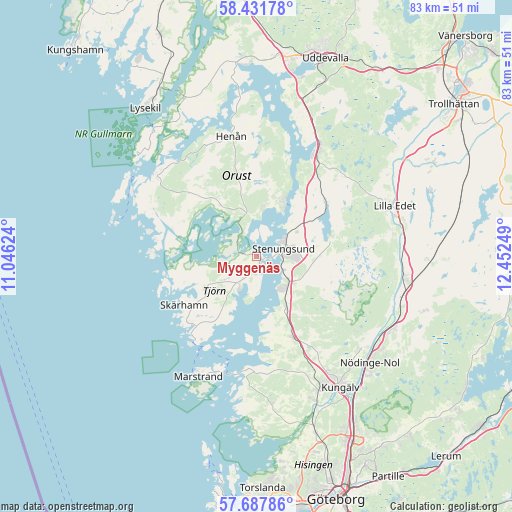
Myggenäs GPS coordinates[2]
58° 3' 42.336" North, 11° 44' 57.696" East
| Map corner | latitude | longitude |
|---|---|---|
| Upper-left | 58.43178°, | 11.04624° |
| Center: | 58.06176°, | 11.74936° |
| Lower-right: | 57.68786°, | 12.45249° |
| Map W x H: | 82.7×82.7 km | = 51.4×51.4mi |
| max Lat: | 67.85572° ⇑59.6% North |
| Myggenäs: | 58.06176° |
| min Lat: | ⇓40.4% South 55.34337° |
| min Long | Myggenäs | max Long |
| 11.1712° | 11.74936° | 24.13676° |
| W 2.4%⇐ | ⇒97.6% E |
Elevation
Elevation of Myggenäs is 22 m = 72 ft, and this is 60.6 m = 199 ft below average elevation for this country.
| Max E: |
663 m = 2175 ft | 72.8% |
| Avg. | 82.6 m = 271 ft | |
| Myggenäs | 22 m = 72 ft | |
Min E: |
-1 m = -3 ft | 27.2% |
See also: Sweden elevation on elevation.city.
Geographical zone
Myggenäs is located in North temperate zone (between Tropic of Cancer and the Arctic Circle). Distance of this North polar circle is 945.3 km =587.4 mi to North.| Distance of | km | miles | from Myggenäs |
|---|---|---|---|
| North Pole | 3551.2 | 2206.6 | to North |
| Arctic Circle | 945.3 | 587.4 | to North |
| Tropic Cancer | 3849.9 | 2392.2 | to South |
| Equator | 6455.9 | 4011.5 | to South |


Nearby cities:
15 places around Myggenäs: (largest is in red/bold)
• Aröd
10.6 km =6.6 mi,  168°
168°
• Höviksnäs
3.3 km =2.1 mi,  162°
162°
• Jörlanda
9.6 km =6 mi,  150°
150°
• Klövedal
10.3 km =6.4 mi,  252°
252°
• Kode
14.5 km =9 mi, 155°
• Kyrkesund
14.6 km =9.1 mi, 249°
• Rönnäng
17.3 km =10.7 mi,  214°
214°
• Skärhamn
14.1 km =8.8 mi,  233°
233°
• Stenungsund
4.2 km =2.6 mi,  76°
76°
• Stora Höga
7 km =4.3 mi,  135°
135°
• Svanesund
9.9 km =6.2 mi,  24°
24°
• Tjuvkil
18 km =11.2 mi,  183°
183°
• Ucklum
12 km =7.5 mi, 78°
• Varekil
7.2 km =4.5 mi,  340°
340°
• Ödsmål
7.3 km =4.5 mi,  54°
54°
Sources, notices
• [Note1] Compared only with cities in Sweden existing in our database
• [Src1] Map data: © OpenStreetMap contributors (CC-BY-SA)
• [Src2] Other city data from geonames.org with taken over terms of usage.
• [Src3] Geographical zone / Annual Mean Temperature by Robert A. Rohde @ Wikipedia
