Stenstorp geodata
Stenstorp (Västra Götaland) is a populated place; located in Sweden in Europe/Stockholm (GMT+2) time zone. With population of 1,823 people, there are 560 cities with bigger population in this country. Compared to other cities in Sweden, 56.9% of cities are located further ↑North; 67.6% of cities are located further →East and 86.4% of cities have lower elevation than Stenstorp. Note1
Administrative division(s):
- Level 1: Västra Götaland
- Level 2: Falköpings Kommun
- Level 3: Stenstorp
- Level 4: Stenstorp socken


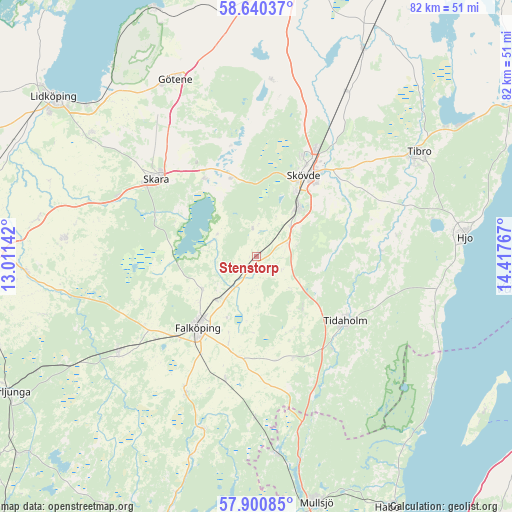
Stenstorp GPS coordinates[2]
58° 16' 21.144" North, 13° 42' 52.344" East
| Map corner | latitude | longitude |
|---|---|---|
| Upper-left | 58.64037°, | 13.01142° |
| Center: | 58.27254°, | 13.71454° |
| Lower-right: | 57.90085°, | 14.41767° |
| Map W x H: | 82.2×82.2 km | = 51.1×51.1mi |
| max Lat: | 67.85572° ⇑56.9% North |
| Stenstorp: | 58.27254° |
| min Lat: | ⇓43.1% South 55.34337° |
| min Long | Stenstorp | max Long |
| 11.1712° | 13.71454° | 24.13676° |
| W 32.4%⇐ | ⇒67.6% E |
Elevation
Elevation of Stenstorp is 175 m = 574 ft, and this is 92.4 m = 303 ft above average elevation for this country.
| Max E: |
663 m = 2175 ft | 13.6% |
| Stenstorp | 175 m 574 ft | |
| Avg. | 82.6 m = 271 ft | |
Min E: |
-1 m = -3 ft | 86.4% |
See also: Sweden elevation on elevation.city.
Geographical zone
Stenstorp is located in North temperate zone (between Tropic of Cancer and the Arctic Circle). Distance of this North polar circle is 921.9 km =572.8 mi to North.| Distance of | km | miles | from Stenstorp |
|---|---|---|---|
| North Pole | 3527.8 | 2192.1 | to North |
| Arctic Circle | 921.9 | 572.8 | to North |
| Tropic Cancer | 3873.4 | 2406.8 | to South |
| Equator | 6479.3 | 4026 | to South |


Nearby cities:
15 places around Stenstorp: (largest is in red/bold)
• Ardala
24.2 km =15 mi,  294°
294°
• Axvall
15 km =9.3 mi,  324°
324°
• Falköping
14.6 km =9.1 mi,  221°
221°
• Igelstorp
20.4 km =12.7 mi,  46°
46°
• Lerdala
22.9 km =14.2 mi,  359°
359°
• Olofstorp
16.9 km =10.5 mi,  98°
98°
• Skara
20.5 km =12.7 mi,  308°
308°
• Skultorp
11.1 km =6.9 mi,  38°
38°
• Skövde
15.2 km =9.4 mi,  30°
30°
• Stöpen
24.5 km =15.2 mi,  21°
21°
• Tidaholm
17.6 km =10.9 mi,  125°
125°
• Varnhem
12.9 km =8 mi,  342°
342°
• Vartofta
19.8 km =12.3 mi,  193°
193°
• Värsås
21.4 km =13.3 mi,  66°
66°
• Åkarp
5.8 km =3.6 mi, 220°
Sources, notices
• [Note1] Compared only with cities in Sweden existing in our database
• [Src1] Map data: © OpenStreetMap contributors (CC-BY-SA)
• [Src2] Other city data from geonames.org with taken over terms of usage.
• [Src3] Geographical zone / Annual Mean Temperature by Robert A. Rohde @ Wikipedia
