Falköping geodata
Falköping (Västra Götaland) is a seat of a second-order administrative division; located in Sweden in Europe/Stockholm (GMT+2) time zone. With population of 17,170 people, there are 90 cities with bigger population in this country. Compared to other cities in Sweden, 58.3% of cities are located further ↑North; 70.1% of cities are located further →East and 91.6% of cities have lower elevation than Falköping. Note1


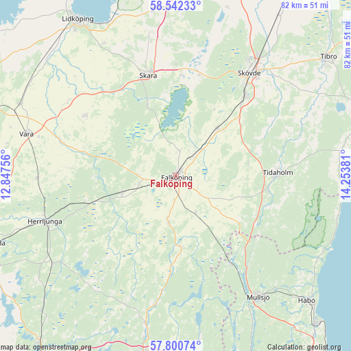
Falköping GPS coordinates[2]
58° 10' 24.492" North, 13° 33' 2.448" East
| Map corner | latitude | longitude |
|---|---|---|
| Upper-left | 58.54233°, | 12.84756° |
| Center: | 58.17347°, | 13.55068° |
| Lower-right: | 57.80074°, | 14.25381° |
| Map W x H: | 82.5×82.5 km | = 51.3×51.3mi |
| max Lat: | 67.85572° ⇑58.3% North |
| Falköping: | 58.17347° |
| min Lat: | ⇓41.7% South 55.34337° |
| min Long | Falköping | max Long |
| 11.1712° | 13.55068° | 24.13676° |
| W 29.9%⇐ | ⇒70.1% E |
Elevation
Elevation of Falköping is 217 m = 712 ft, and this is 134.4 m = 441 ft above average elevation for this country.
| Max E: |
663 m = 2175 ft | 8.4% |
| Falköping | 217 m 712 ft | |
| Avg. | 82.6 m = 271 ft | |
Min E: |
-1 m = -3 ft | 91.6% |
See also: Sweden elevation on elevation.city.
Geographical zone
Falköping is located in North temperate zone (between Tropic of Cancer and the Arctic Circle). Distance of this North polar circle is 932.9 km =579.7 mi to North.| Distance of | km | miles | from Falköping |
|---|---|---|---|
| North Pole | 3538.8 | 2198.9 | to North |
| Arctic Circle | 932.9 | 579.7 | to North |
| Tropic Cancer | 3862.4 | 2400 | to South |
| Equator | 6468.3 | 4019.2 | to South |


Nearby cities:
15 places around Falköping: (largest is in red/bold)
• Ardala
24.4 km =15.2 mi,  329°
329°
• Axvall
23.4 km =14.5 mi,  2°
2°
• Floby
13.5 km =8.4 mi,  250°
250°
• Kinnarp
10.8 km =6.7 mi,  189°
189°
• Kvänum
25.7 km =16 mi,  303°
303°
• Sandhem
17.9 km =11.1 mi, 192°
• Sandhem
24.7 km =15.3 mi,  149°
149°
• Skara
24.6 km =15.3 mi,  344°
344°
• Skultorp
25.7 km =16 mi,  40°
40°
• Stenstorp
14.6 km =9.1 mi, 41°
• Tidaholm
23.9 km =14.9 mi,  88°
88°
• Varnhem
24 km =14.9 mi,  13°
13°
• Vartofta
9.5 km =5.9 mi, 149°
• Åkarp
8.8 km =5.5 mi, 41°
• Åsarp
16.6 km =10.3 mi,  177°
177°
Sources, notices
• [Note1] Compared only with cities in Sweden existing in our database
• [Src1] Map data: © OpenStreetMap contributors (CC-BY-SA)
• [Src2] Other city data from geonames.org with taken over terms of usage.
• [Src3] Geographical zone / Annual Mean Temperature by Robert A. Rohde @ Wikipedia
