Tidaholm geodata
Tidaholm (Västra Götaland) is a seat of a second-order administrative division; located in Sweden in Europe/Stockholm (GMT+2) time zone. With population of 8,175 people, there are 177 cities with bigger population in this country. Compared to other cities in Sweden, 58.2% of cities are located further ↑North; 64.9% of cities are located further →East and 80.9% of cities have lower elevation than Tidaholm. Note1


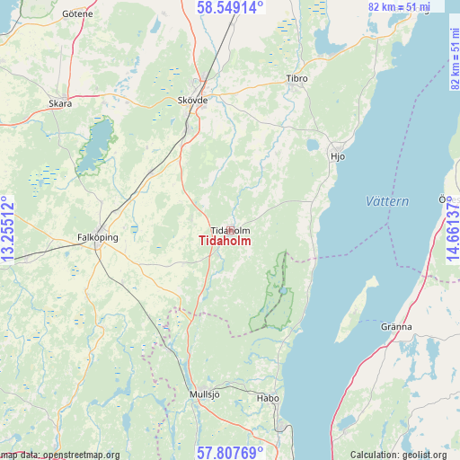
Tidaholm GPS coordinates[2]
58° 10' 49.26" North, 13° 57' 29.664" East
| Map corner | latitude | longitude |
|---|---|---|
| Upper-left | 58.54914°, | 13.25512° |
| Center: | 58.18035°, | 13.95824° |
| Lower-right: | 57.80769°, | 14.66137° |
| Map W x H: | 82.4×82.4 km | = 51.2×51.2mi |
| max Lat: | 67.85572° ⇑58.2% North |
| Tidaholm: | 58.18035° |
| min Lat: | ⇓41.8% South 55.34337° |
| min Long | Tidaholm | max Long |
| 11.1712° | 13.95824° | 24.13676° |
| W 35.1%⇐ | ⇒64.9% E |
Elevation
Elevation of Tidaholm is 148 m = 486 ft, and this is 65.4 m = 215 ft above average elevation for this country.
| Max E: |
663 m = 2175 ft | 19.1% |
| Tidaholm | 148 m 486 ft | |
| Avg. | 82.6 m = 271 ft | |
Min E: |
-1 m = -3 ft | 80.9% |
See also: Sweden elevation on elevation.city.
Geographical zone
Tidaholm is located in North temperate zone (between Tropic of Cancer and the Arctic Circle). Distance of this North polar circle is 932.1 km =579.2 mi to North.| Distance of | km | miles | from Tidaholm |
|---|---|---|---|
| North Pole | 3538 | 2198.4 | to North |
| Arctic Circle | 932.1 | 579.2 | to North |
| Tropic Cancer | 3863.1 | 2400.4 | to South |
| Equator | 6469 | 4019.6 | to South |


Nearby cities:
15 places around Tidaholm: (largest is in red/bold)
• Falköping
23.9 km =14.9 mi,  268°
268°
• Hjo
23.5 km =14.6 mi,  55°
55°
• Igelstorp
24.4 km =15.2 mi,  1°
1°
• Kinnarp
28.1 km =17.5 mi,  246°
246°
• Olofstorp
8.1 km =5 mi,  17°
17°
• Sandhem
24.6 km =15.3 mi,  207°
207°
• Skultorp
20.2 km =12.6 mi,  338°
338°
• Skövde
24.4 km =15.2 mi, 344°
• Stenstorp
17.6 km =10.9 mi,  305°
305°
• Tibro
29.6 km =18.4 mi, 23°
• Varnhem
28.9 km =18 mi,  321°
321°
• Vartofta
21.1 km =13.1 mi,  244°
244°
• Värsås
19.6 km =12.2 mi, 15°
• Åkarp
19 km =11.8 mi,  288°
288°
• Åsarp
28.9 km =18 mi,  233°
233°
Sources, notices
• [Note1] Compared only with cities in Sweden existing in our database
• [Src1] Map data: © OpenStreetMap contributors (CC-BY-SA)
• [Src2] Other city data from geonames.org with taken over terms of usage.
• [Src3] Geographical zone / Annual Mean Temperature by Robert A. Rohde @ Wikipedia
