Axvall geodata
Axvall (Västra Götaland) is a populated place; located in Sweden in Europe/Stockholm (GMT+2) time zone. With population of 1,164 people, there are 756 cities with bigger population in this country. Compared to other cities in Sweden, 55% of cities are located further ↑North; 69.9% of cities are located further →East and 77.1% of cities have lower elevation than Axvall. Note1


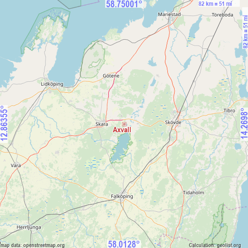
Axvall GPS coordinates[2]
58° 22' 59.988" North, 13° 34' 0.012" East
| Map corner | latitude | longitude |
|---|---|---|
| Upper-left | 58.75001°, | 12.86355° |
| Center: | 58.38333°, | 13.56667° |
| Lower-right: | 58.0128°, | 14.2698° |
| Map W x H: | 82×82 km | = 51×51mi |
| max Lat: | 67.85572° ⇑55% North |
| Axvall: | 58.38333° |
| min Lat: | ⇓45% South 55.34337° |
| min Long | Axvall | max Long |
| 11.1712° | 13.56667° | 24.13676° |
| W 30.1%⇐ | ⇒69.9% E |
Elevation
Elevation of Axvall is 129 m = 423 ft, and this is 46.4 m = 152 ft above average elevation for this country.
| Max E: |
663 m = 2175 ft | 22.9% |
| Axvall | 129 m 423 ft | |
| Avg. | 82.6 m = 271 ft | |
Min E: |
-1 m = -3 ft | 77.1% |
See also: Sweden elevation on elevation.city.
Geographical zone
Axvall is located in North temperate zone (between Tropic of Cancer and the Arctic Circle). Distance of this North polar circle is 909.6 km =565.2 mi to North.| Distance of | km | miles | from Axvall |
|---|---|---|---|
| North Pole | 3515.4 | 2184.4 | to North |
| Arctic Circle | 909.6 | 565.2 | to North |
| Tropic Cancer | 3885.7 | 2414.5 | to South |
| Equator | 6491.6 | 4033.7 | to South |


Nearby cities:
15 places around Axvall: (largest is in red/bold)
• Ardala
13.6 km =8.5 mi,  259°
259°
• Filsbäck
22.2 km =13.8 mi,  303°
303°
• Götene
16.6 km =10.3 mi,  345°
345°
• Källby
20.7 km =12.9 mi,  312°
312°
• Lerdala
13.6 km =8.5 mi,  38°
38°
• Lundsbrunn
12 km =7.5 mi,  324°
324°
• Skara
7.5 km =4.7 mi,  272°
272°
• Skultorp
16 km =9.9 mi,  103°
103°
• Skövde
16.2 km =10.1 mi,  86°
86°
• Stenstorp
15 km =9.3 mi,  144°
144°
• Stöpen
20.4 km =12.7 mi,  58°
58°
• Timmersdala
19.8 km =12.3 mi,  32°
32°
• Varnhem
4.9 km =3 mi, 90°
• Vinninga
19 km =11.8 mi,  292°
292°
• Åkarp
17.4 km =10.8 mi,  163°
163°
Sources, notices
• [Note1] Compared only with cities in Sweden existing in our database
• [Src1] Map data: © OpenStreetMap contributors (CC-BY-SA)
• [Src2] Other city data from geonames.org with taken over terms of usage.
• [Src3] Geographical zone / Annual Mean Temperature by Robert A. Rohde @ Wikipedia
