Stenkullen geodata
Stenkullen (Västra Götaland) is a populated place; located in Sweden in Europe/Stockholm (GMT+2) time zone. With population of 2,000 people, there are 519 cities with bigger population in this country. Compared to other cities in Sweden, 64.4% of cities are located further ↑North; 90.3% of cities are located further →East and 52.1% of cities have lower elevation than Stenkullen. Note1
Administrative division(s):
- Level 1: Västra Götaland
- Level 2: Lerums Kommun
- Level 3: Lerum
- Level 4: Lerum socken


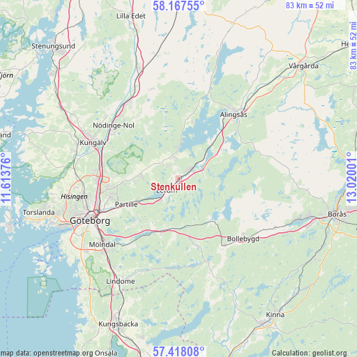
Stenkullen GPS coordinates[2]
57° 47' 41.136" North, 12° 19' 0.768" East
| Map corner | latitude | longitude |
|---|---|---|
| Upper-left | 58.16755°, | 11.61376° |
| Center: | 57.79476°, | 12.31688° |
| Lower-right: | 57.41808°, | 13.02001° |
| Map W x H: | 83.3×83.3 km | = 51.8×51.8mi |
| max Lat: | 67.85572° ⇑64.4% North |
| Stenkullen: | 57.79476° |
| min Lat: | ⇓35.6% South 55.34337° |
| min Long | Stenkullen | max Long |
| 11.1712° | 12.31688° | 24.13676° |
| W 9.7%⇐ | ⇒90.3% E |
Elevation
Elevation of Stenkullen is 54 m = 177 ft, and this is 28.6 m = 94 ft below average elevation for this country.
| Max E: |
663 m = 2175 ft | 47.9% |
| Avg. | 82.6 m = 271 ft | |
| Stenkullen | 54 m = 177 ft | |
Min E: |
-1 m = -3 ft | 52.1% |
See also: Sweden elevation on elevation.city.
Geographical zone
Stenkullen is located in North temperate zone (between Tropic of Cancer and the Arctic Circle). Distance of this North polar circle is 975 km =605.8 mi to North.| Distance of | km | miles | from Stenkullen |
|---|---|---|---|
| North Pole | 3580.9 | 2225.1 | to North |
| Arctic Circle | 975 | 605.8 | to North |
| Tropic Cancer | 3820.3 | 2373.8 | to South |
| Equator | 6426.2 | 3993.1 | to South |


Nearby cities:
15 places around Stenkullen: (largest is in red/bold)
• Angered
13 km =8.1 mi,  265°
265°
• Björboholm
8.5 km =5.3 mi,  3°
3°
• Furulund
13.9 km =8.6 mi,  231°
231°
• Gråbo
4.7 km =2.9 mi,  347°
347°
• Hindås
12.7 km =7.9 mi,  142°
142°
• Ingared
10.8 km =6.7 mi,  47°
47°
• Jonsered
10.1 km =6.3 mi,  237°
237°
• Kåhög
10.9 km =6.8 mi, 243°
• Landvetter
13.5 km =8.4 mi,  207°
207°
• Lerum
3.9 km =2.4 mi, 226°
• Olofstorp
8.7 km =5.4 mi,  277°
277°
• Olstorp
3.9 km =2.4 mi,  322°
322°
• Sjövik
13.9 km =8.6 mi,  12°
12°
• Tollered
6.4 km =4 mi,  67°
67°
• Öxeryd
6.9 km =4.3 mi,  199°
199°
Sources, notices
• [Note1] Compared only with cities in Sweden existing in our database
• [Src1] Map data: © OpenStreetMap contributors (CC-BY-SA)
• [Src2] Other city data from geonames.org with taken over terms of usage.
• [Src3] Geographical zone / Annual Mean Temperature by Robert A. Rohde @ Wikipedia
