Olofstorp geodata
Olofstorp (Västra Götaland) is a populated place; located in Sweden in Europe/Stockholm (GMT+2) time zone. With population of 3,746 people, there are 346 cities with bigger population in this country. Compared to other cities in Sweden, 64.1% of cities are located further ↑North; 92.2% of cities are located further →East and 60.4% of cities have lower elevation than Olofstorp. Note1


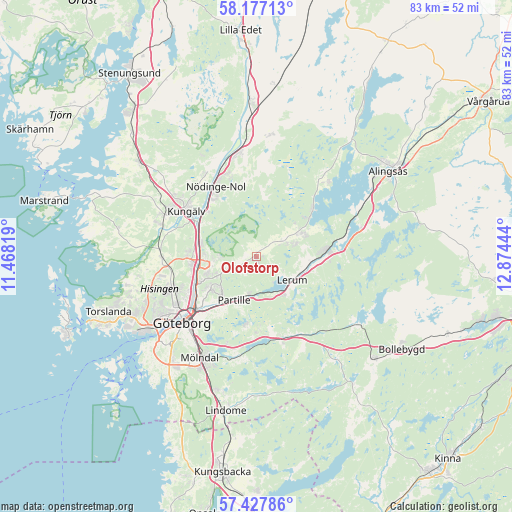
Olofstorp GPS coordinates[2]
57° 48' 15.984" North, 12° 10' 16.716" East
| Map corner | latitude | longitude |
|---|---|---|
| Upper-left | 58.17713°, | 11.46819° |
| Center: | 57.80444°, | 12.17131° |
| Lower-right: | 57.42786°, | 12.87444° |
| Map W x H: | 83.3×83.3 km | = 51.8×51.8mi |
| max Lat: | 67.85572° ⇑64.1% North |
| Olofstorp: | 57.80444° |
| min Lat: | ⇓35.9% South 55.34337° |
| min Long | Olofstorp | max Long |
| 11.1712° | 12.17131° | 24.13676° |
| W 7.8%⇐ | ⇒92.2% E |
Elevation
Elevation of Olofstorp is 72 m = 236 ft, and this is 10.6 m = 35 ft below average elevation for this country.
| Max E: |
663 m = 2175 ft | 39.6% |
| Avg. | 82.6 m = 271 ft | |
| Olofstorp | 72 m = 236 ft | |
Min E: |
-1 m = -3 ft | 60.4% |
See also: Sweden elevation on elevation.city.
Geographical zone
Olofstorp is located in North temperate zone (between Tropic of Cancer and the Arctic Circle). Distance of this North polar circle is 973.9 km =605.2 mi to North.| Distance of | km | miles | from Olofstorp |
|---|---|---|---|
| North Pole | 3579.8 | 2224.4 | to North |
| Arctic Circle | 973.9 | 605.2 | to North |
| Tropic Cancer | 3821.3 | 2374.4 | to South |
| Equator | 6427.3 | 3993.7 | to South |


Nearby cities:
15 places around Olofstorp: (largest is in red/bold)
• Angered
4.8 km =3 mi,  244°
244°
• Eriksbo
8.5 km =5.3 mi, 244°
• Gråbo
8.4 km =5.2 mi,  65°
65°
• Gårdsten
8.4 km =5.2 mi,  270°
270°
• Hammarkullen
8.4 km =5.2 mi,  251°
251°
• Jonsered
6.5 km =4 mi,  178°
178°
• Kåhög
6.1 km =3.8 mi,  190°
190°
• Lerum
6.9 km =4.3 mi,  123°
123°
• Lövgärdet
8 km =5 mi,  278°
278°
• Olstorp
6.6 km =4.1 mi, 71°
• Partille
8.2 km =5.1 mi,  208°
208°
• Rannebergen
5.9 km =3.7 mi, 267°
• Stenkullen
8.7 km =5.4 mi,  97°
97°
• Surte
9.5 km =5.9 mi, 284°
• Öxeryd
9.9 km =6.2 mi,  139°
139°
Sources, notices
• [Note1] Compared only with cities in Sweden existing in our database
• [Src1] Map data: © OpenStreetMap contributors (CC-BY-SA)
• [Src2] Other city data from geonames.org with taken over terms of usage.
• [Src3] Geographical zone / Annual Mean Temperature by Robert A. Rohde @ Wikipedia
