Lerum geodata
Lerum (Västra Götaland) is a seat of a second-order administrative division; located in Sweden in Europe/Stockholm (GMT+2) time zone. With population of 26,913 people, there are 58 cities with bigger population in this country. Compared to other cities in Sweden, 65.3% of cities are located further ↑North; 91.2% of cities are located further →East and 75.3% of cities have higher elevation than Lerum. Note1


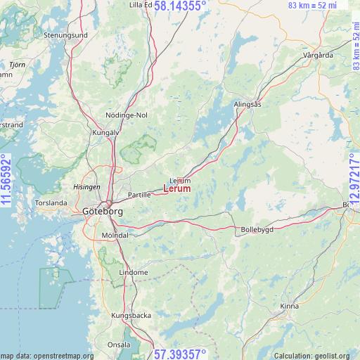
Lerum GPS coordinates[2]
57° 46' 13.836" North, 12° 16' 8.544" East
| Map corner | latitude | longitude |
|---|---|---|
| Upper-left | 58.14355°, | 11.56592° |
| Center: | 57.77051°, | 12.26904° |
| Lower-right: | 57.39357°, | 12.97217° |
| Map W x H: | 83.4×83.4 km | = 51.8×51.8mi |
| max Lat: | 67.85572° ⇑65.3% North |
| Lerum: | 57.77051° |
| min Lat: | ⇓34.7% South 55.34337° |
| min Long | Lerum | max Long |
| 11.1712° | 12.26904° | 24.13676° |
| W 8.8%⇐ | ⇒91.2% E |
Elevation
Elevation of Lerum is 20 m = 66 ft, and this is 62.6 m = 205 ft below average elevation for this country.
| Max E: |
663 m = 2175 ft | 75.3% |
| Avg. | 82.6 m = 271 ft | |
| Lerum | 20 m = 66 ft | |
Min E: |
-1 m = -3 ft | 24.7% |
See also: Sweden elevation on elevation.city.
Geographical zone
Lerum is located in North temperate zone (between Tropic of Cancer and the Arctic Circle). Distance of this North polar circle is 977.7 km =607.5 mi to North.| Distance of | km | miles | from Lerum |
|---|---|---|---|
| North Pole | 3583.6 | 2226.7 | to North |
| Arctic Circle | 977.7 | 607.5 | to North |
| Tropic Cancer | 3817.6 | 2372.1 | to South |
| Equator | 6423.5 | 3991.4 | to South |


Nearby cities:
15 places around Lerum: (largest is in red/bold)
• Angered
10.3 km =6.4 mi,  279°
279°
• Björboholm
11.7 km =7.3 mi,  16°
16°
• Furulund
10 km =6.2 mi,  233°
233°
• Gråbo
7.5 km =4.7 mi,  13°
13°
• Jonsered
6.3 km =3.9 mi,  244°
244°
• Kåhög
7.3 km =4.5 mi,  252°
252°
• Landvetter
9.9 km =6.2 mi,  200°
200°
• Olofstorp
6.9 km =4.3 mi,  303°
303°
• Olstorp
5.8 km =3.6 mi,  4°
4°
• Partille
10.2 km =6.3 mi, 250°
• Rannebergen
12.2 km =7.6 mi,  286°
286°
• Stenkullen
3.9 km =2.4 mi,  46°
46°
• Tollered
10.1 km =6.3 mi,  59°
59°
• Öjersjö
11.3 km =7 mi, 225°
• Öxeryd
3.9 km =2.4 mi,  171°
171°
Sources, notices
• [Note1] Compared only with cities in Sweden existing in our database
• [Src1] Map data: © OpenStreetMap contributors (CC-BY-SA)
• [Src2] Other city data from geonames.org with taken over terms of usage.
• [Src3] Geographical zone / Annual Mean Temperature by Robert A. Rohde @ Wikipedia
