Ingared geodata
Ingared (Västra Götaland) is a populated place; located in Sweden in Europe/Stockholm (GMT+2) time zone. With population of 1,703 people, there are 595 cities with bigger population in this country. Compared to other cities in Sweden, 62.9% of cities are located further ↑North; 88.8% of cities are located further →East and 63.6% of cities have lower elevation than Ingared. Note1


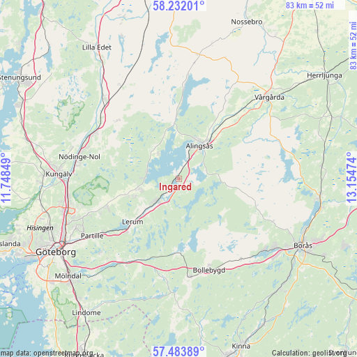
Ingared GPS coordinates[2]
57° 51' 35.604" North, 12° 27' 5.796" East
| Map corner | latitude | longitude |
|---|---|---|
| Upper-left | 58.23201°, | 11.74849° |
| Center: | 57.85989°, | 12.45161° |
| Lower-right: | 57.48389°, | 13.15474° |
| Map W x H: | 83.2×83.2 km | = 51.7×51.7mi |
| max Lat: | 67.85572° ⇑62.9% North |
| Ingared: | 57.85989° |
| min Lat: | ⇓37.1% South 55.34337° |
| min Long | Ingared | max Long |
| 11.1712° | 12.45161° | 24.13676° |
| W 11.2%⇐ | ⇒88.8% E |
Elevation
Elevation of Ingared is 79 m = 259 ft, and this is 3.6 m = 12 ft below average elevation for this country.
| Max E: |
663 m = 2175 ft | 36.4% |
| Avg. | 82.6 m = 271 ft | |
| Ingared | 79 m = 259 ft | |
Min E: |
-1 m = -3 ft | 63.6% |
See also: Sweden elevation on elevation.city.
Geographical zone
Ingared is located in North temperate zone (between Tropic of Cancer and the Arctic Circle). Distance of this North polar circle is 967.8 km =601.4 mi to North.| Distance of | km | miles | from Ingared |
|---|---|---|---|
| North Pole | 3573.6 | 2220.5 | to North |
| Arctic Circle | 967.8 | 601.4 | to North |
| Tropic Cancer | 3827.5 | 2378.3 | to South |
| Equator | 6433.4 | 3997.5 | to South |


Nearby cities:
15 places around Ingared: (largest is in red/bold)
• Alingsås
9.2 km =5.7 mi,  31°
31°
• Björboholm
7.6 km =4.7 mi,  279°
279°
• Glommen
10.1 km =6.3 mi,  323°
323°
• Gråbo
9.4 km =5.8 mi,  253°
253°
• Hindås
17.4 km =10.8 mi,  180°
180°
• Jonsered
20.8 km =12.9 mi,  232°
232°
• Lerum
14.7 km =9.1 mi, 227°
• Olofstorp
17.7 km =11 mi, 249°
• Olstorp
11.1 km =6.9 mi, 248°
• Sjövik
8.1 km =5 mi, 321°
• Skepplanda
20.2 km =12.6 mi,  312°
312°
• Stenkullen
10.8 km =6.7 mi, 227°
• Sålanda
19.5 km =12.1 mi, 314°
• Tollered
5.2 km =3.2 mi,  203°
203°
• Öxeryd
17.1 km =10.6 mi,  216°
216°
Sources, notices
• [Note1] Compared only with cities in Sweden existing in our database
• [Src1] Map data: © OpenStreetMap contributors (CC-BY-SA)
• [Src2] Other city data from geonames.org with taken over terms of usage.
• [Src3] Geographical zone / Annual Mean Temperature by Robert A. Rohde @ Wikipedia
