Skillingaryd geodata
Skillingaryd (Jönköping) is a populated place; located in Sweden in Europe/Stockholm (GMT+2) time zone. With population of 3,965 people, there are 323 cities with bigger population in this country. Compared to other cities in Sweden, 72.6% of cities are located further ↑North; 63.2% of cities are located further →East and 88.5% of cities have lower elevation than Skillingaryd. Note1
Administrative division(s):
- Level 1: Jönköping
- Level 2: Vaggeryds Kommun
- Level 3: Tofteryd
- Level 4: Tofteryd socken


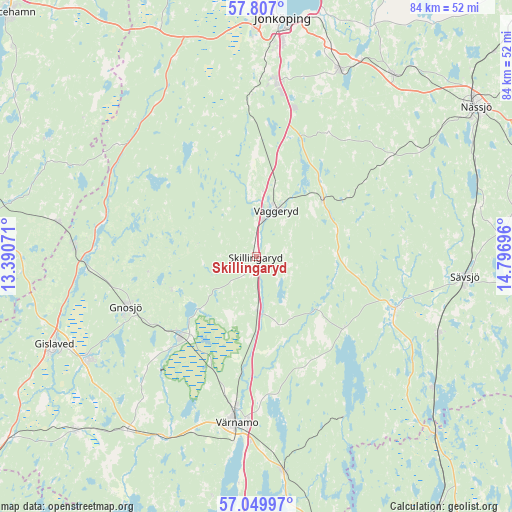
Skillingaryd GPS coordinates[2]
57° 25' 49.584" North, 14° 5' 37.788" East
| Map corner | latitude | longitude |
|---|---|---|
| Upper-left | 57.807°, | 13.39071° |
| Center: | 57.43044°, | 14.09383° |
| Lower-right: | 57.04997°, | 14.79696° |
| Map W x H: | 84.2×84.2 km | = 52.3×52.3mi |
| max Lat: | 67.85572° ⇑72.6% North |
| Skillingaryd: | 57.43044° |
| min Lat: | ⇓27.4% South 55.34337° |
| min Long | Skillingaryd | max Long |
| 11.1712° | 14.09383° | 24.13676° |
| W 36.8%⇐ | ⇒63.2% E |
Elevation
Elevation of Skillingaryd is 188 m = 617 ft, and this is 105.4 m = 346 ft above average elevation for this country.
| Max E: |
663 m = 2175 ft | 11.5% |
| Skillingaryd | 188 m 617 ft | |
| Avg. | 82.6 m = 271 ft | |
Min E: |
-1 m = -3 ft | 88.5% |
See also: Sweden elevation on elevation.city.
Geographical zone
Skillingaryd is located in North temperate zone (between Tropic of Cancer and the Arctic Circle). Distance of this North polar circle is 1015.5 km =631 mi to North.| Distance of | km | miles | from Skillingaryd |
|---|---|---|---|
| North Pole | 3621.4 | 2250.2 | to North |
| Arctic Circle | 1015.5 | 631 | to North |
| Tropic Cancer | 3779.7 | 2348.6 | to South |
| Equator | 6385.7 | 3967.9 | to South |


Nearby cities:
15 places around Skillingaryd: (largest is in red/bold)
• Anderstorp
32.1 km =19.9 mi,  239°
239°
• Barnarp
30.8 km =19.1 mi,  9°
9°
• Gnosjö
22.8 km =14.2 mi,  249°
249°
• Hestra
29.8 km =18.5 mi,  272°
272°
• Hillerstorp
18.1 km =11.2 mi,  223°
223°
• Hok
14.5 km =9 mi,  49°
49°
• Linneryd
4.8 km =3 mi,  135°
135°
• Malmbäck
27.3 km =17 mi, 53°
• Marieholm
15.5 km =9.6 mi, 250°
• Odensjö
32.1 km =19.9 mi, 7°
• Stockaryd
32.5 km =20.2 mi,  112°
112°
• Taberg
27.4 km =17 mi,  359°
359°
• Vaggeryd
8.2 km =5.1 mi,  23°
23°
• Vrigstad
24.1 km =15 mi, 111°
• Värnamo
27.4 km =17 mi,  186°
186°
Sources, notices
• [Note1] Compared only with cities in Sweden existing in our database
• [Src1] Map data: © OpenStreetMap contributors (CC-BY-SA)
• [Src2] Other city data from geonames.org with taken over terms of usage.
• [Src3] Geographical zone / Annual Mean Temperature by Robert A. Rohde @ Wikipedia
