Linneryd geodata
Linneryd (Jönköping) is a populated place; located in Sweden in Europe/Stockholm (GMT+2) time zone. With population of 541 people, there are 1250 cities with bigger population in this country. Compared to other cities in Sweden, 73.2% of cities are located further ↑North; 62.1% of cities are located further →East and 88.1% of cities have lower elevation than Linneryd. Note1


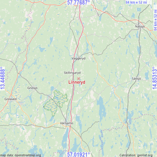
Linneryd GPS coordinates[2]
57° 24' 0" North, 14° 9' 0" East
| Map corner | latitude | longitude |
|---|---|---|
| Upper-left | 57.77687°, | 13.44688° |
| Center: | 57.4°, | 14.15° |
| Lower-right: | 57.01921°, | 14.85313° |
| Map W x H: | 84.2×84.2 km | = 52.3×52.3mi |
| max Lat: | 67.85572° ⇑73.2% North |
| Linneryd: | 57.4° |
| min Lat: | ⇓26.8% South 55.34337° |
| min Long | Linneryd | max Long |
| 11.1712° | 14.15° | 24.13676° |
| W 37.9%⇐ | ⇒62.1% E |
Elevation
Elevation of Linneryd is 184 m = 604 ft, and this is 101.4 m = 333 ft above average elevation for this country.
| Max E: |
663 m = 2175 ft | 11.9% |
| Linneryd | 184 m 604 ft | |
| Avg. | 82.6 m = 271 ft | |
Min E: |
-1 m = -3 ft | 88.1% |
See also: Sweden elevation on elevation.city.
Geographical zone
Linneryd is located in North temperate zone (between Tropic of Cancer and the Arctic Circle). Distance of this North polar circle is 1018.9 km =633.1 mi to North.| Distance of | km | miles | from Linneryd |
|---|---|---|---|
| North Pole | 3624.8 | 2252.3 | to North |
| Arctic Circle | 1018.9 | 633.1 | to North |
| Tropic Cancer | 3776.4 | 2346.5 | to South |
| Equator | 6382.3 | 3965.8 | to South |


Nearby cities:
15 places around Linneryd: (largest is in red/bold)
• Bor
31.5 km =19.6 mi,  178°
178°
• Forsheda
32.5 km =20.2 mi,  216°
216°
• Gnosjö
25.2 km =15.7 mi,  259°
259°
• Hillerstorp
18.6 km =11.6 mi,  238°
238°
• Hok
14.9 km =9.3 mi,  30°
30°
• Malmbäck
27.1 km =16.8 mi,  43°
43°
• Marieholm
18.1 km =11.2 mi, 264°
• Rörvik
31.3 km =19.4 mi,  125°
125°
• Skillingaryd
4.8 km =3 mi,  315°
315°
• Stockaryd
28.1 km =17.5 mi,  109°
109°
• Sävsjö
30.7 km =19.1 mi,  89°
89°
• Taberg
31 km =19.3 mi,  353°
353°
• Vaggeryd
10.9 km =6.8 mi,  359°
359°
• Vrigstad
19.8 km =12.3 mi, 106°
• Värnamo
24.7 km =15.3 mi,  195°
195°
Sources, notices
• [Note1] Compared only with cities in Sweden existing in our database
• [Src1] Map data: © OpenStreetMap contributors (CC-BY-SA)
• [Src2] Other city data from geonames.org with taken over terms of usage.
• [Src3] Geographical zone / Annual Mean Temperature by Robert A. Rohde @ Wikipedia
