Hestra geodata
Hestra (Jönköping) is a populated place; located in Sweden in Europe/Stockholm (GMT+2) time zone. With population of 1,327 people, there are 702 cities with bigger population in this country. Compared to other cities in Sweden, 72.5% of cities are located further ↑North; 69.5% of cities are located further →East and 88.2% of cities have lower elevation than Hestra. Note1
Administrative division(s):
- Level 1: Jönköping
- Level 2: Gislaveds Kommun
- Level 3: Norra Hestra
- Level 4: Norra Hestra socken


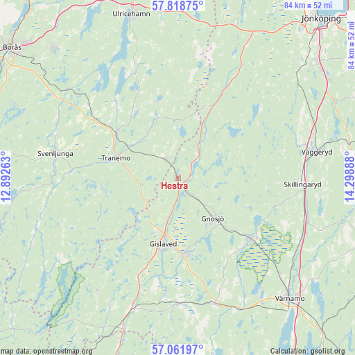
Hestra GPS coordinates[2]
57° 26' 32.352" North, 13° 35' 44.7" East
| Map corner | latitude | longitude |
|---|---|---|
| Upper-left | 57.81875°, | 12.89263° |
| Center: | 57.44232°, | 13.59575° |
| Lower-right: | 57.06197°, | 14.29888° |
| Map W x H: | 84.1×84.1 km | = 52.3×52.3mi |
| max Lat: | 67.85572° ⇑72.5% North |
| Hestra: | 57.44232° |
| min Lat: | ⇓27.5% South 55.34337° |
| min Long | Hestra | max Long |
| 11.1712° | 13.59575° | 24.13676° |
| W 30.5%⇐ | ⇒69.5% E |
Elevation
Elevation of Hestra is 185 m = 607 ft, and this is 102.4 m = 336 ft above average elevation for this country.
| Max E: |
663 m = 2175 ft | 11.8% |
| Hestra | 185 m 607 ft | |
| Avg. | 82.6 m = 271 ft | |
Min E: |
-1 m = -3 ft | 88.2% |
See also: Sweden elevation on elevation.city.
Geographical zone
Hestra is located in North temperate zone (between Tropic of Cancer and the Arctic Circle). Distance of this North polar circle is 1014.2 km =630.2 mi to North.| Distance of | km | miles | from Hestra |
|---|---|---|---|
| North Pole | 3620.1 | 2249.4 | to North |
| Arctic Circle | 1014.2 | 630.2 | to North |
| Tropic Cancer | 3781.1 | 2349.5 | to South |
| Equator | 6387 | 3968.7 | to South |


Nearby cities:
15 places around Hestra: (largest is in red/bold)
• Anderstorp
17.8 km =11.1 mi,  172°
172°
• Dalstorp
18.5 km =11.5 mi,  346°
346°
• Gislaved
15.7 km =9.8 mi,  192°
192°
• Gnosjö
12.6 km =7.8 mi,  137°
137°
• Grimsås
5.4 km =3.4 mi,  329°
329°
• Gällstad
26.8 km =16.7 mi,  338°
338°
• Hillerstorp
22.5 km =14 mi,  129°
129°
• Limmared
17.7 km =11 mi,  305°
305°
• Länghem
27.9 km =17.3 mi, 309°
• Marieholm
16.6 km =10.3 mi,  113°
113°
• Reftele
29.8 km =18.5 mi,  180°
180°
• Skillingaryd
29.8 km =18.5 mi,  92°
92°
• Svenljunga
29.6 km =18.4 mi,  281°
281°
• Tranemo
15.4 km =9.6 mi,  287°
287°
• Vegby
29.6 km =18.4 mi, 334°
Sources, notices
• [Note1] Compared only with cities in Sweden existing in our database
• [Src1] Map data: © OpenStreetMap contributors (CC-BY-SA)
• [Src2] Other city data from geonames.org with taken over terms of usage.
• [Src3] Geographical zone / Annual Mean Temperature by Robert A. Rohde @ Wikipedia
