Sålanda geodata
Sålanda (Västra Götaland) is a populated place; located in Sweden in Europe/Stockholm (GMT+2) time zone. With population of 4,240 people, there are 312 cities with bigger population in this country. Compared to other cities in Sweden, 61.1% of cities are located further ↑North; 91.7% of cities are located further →East and 73.7% of cities have higher elevation than Sålanda. Note1


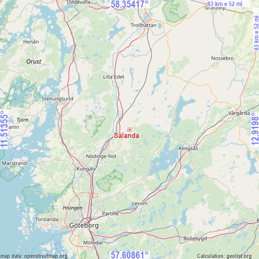
Sålanda GPS coordinates[2]
57° 58' 59.988" North, 12° 13' 0.012" East
| Map corner | latitude | longitude |
|---|---|---|
| Upper-left | 58.35417°, | 11.51355° |
| Center: | 57.98333°, | 12.21667° |
| Lower-right: | 57.60861°, | 12.9198° |
| Map W x H: | 82.9×82.9 km | = 51.5×51.5mi |
| max Lat: | 67.85572° ⇑61.1% North |
| Sålanda: | 57.98333° |
| min Lat: | ⇓38.9% South 55.34337° |
| min Long | Sålanda | max Long |
| 11.1712° | 12.21667° | 24.13676° |
| W 8.3%⇐ | ⇒91.7% E |
Elevation
Elevation of Sålanda is 21 m = 69 ft, and this is 61.6 m = 202 ft below average elevation for this country.
| Max E: |
663 m = 2175 ft | 73.7% |
| Avg. | 82.6 m = 271 ft | |
| Sålanda | 21 m = 69 ft | |
Min E: |
-1 m = -3 ft | 26.3% |
See also: Sweden elevation on elevation.city.
Geographical zone
Sålanda is located in North temperate zone (between Tropic of Cancer and the Arctic Circle). Distance of this North polar circle is 954 km =592.8 mi to North.| Distance of | km | miles | from Sålanda |
|---|---|---|---|
| North Pole | 3559.9 | 2212 | to North |
| Arctic Circle | 954 | 592.8 | to North |
| Tropic Cancer | 3841.2 | 2386.8 | to South |
| Equator | 6447.1 | 4006 | to South |


Nearby cities:
15 places around Sålanda: (largest is in red/bold)
• Alafors
10.4 km =6.5 mi,  231°
231°
• Björboholm
14 km =8.7 mi,  152°
152°
• Diseröd
12.9 km =8 mi,  240°
240°
• Glommen
9.6 km =6 mi,  125°
125°
• Gråbo
17.1 km =10.6 mi,  163°
163°
• Göta
14.2 km =8.8 mi,  344°
344°
• Kungälv
18.7 km =11.6 mi, 228°
• Lilla Edet
17.4 km =10.8 mi, 343°
• Lödöse
6.2 km =3.9 mi,  326°
326°
• Olstorp
18.2 km =11.3 mi,  168°
168°
• Sjövik
11.5 km =7.1 mi, 129°
• Skepplanda
1 km =0.6 mi,  270°
270°
• Tollered
7.8 km =4.8 mi, 241°
• Ucklum
19.2 km =11.9 mi,  305°
305°
• Älvängen
6.1 km =3.8 mi, 243°
Sources, notices
• [Note1] Compared only with cities in Sweden existing in our database
• [Src1] Map data: © OpenStreetMap contributors (CC-BY-SA)
• [Src2] Other city data from geonames.org with taken over terms of usage.
• [Src3] Geographical zone / Annual Mean Temperature by Robert A. Rohde @ Wikipedia
