Lilla Edet geodata
Lilla Edet (Västra Götaland) is a seat of a second-order administrative division; located in Sweden in Europe/Stockholm (GMT+2) time zone. With population of 3,772 people, there are 343 cities with bigger population in this country. Compared to other cities in Sweden, 58.8% of cities are located further ↑North; 93.1% of cities are located further →East and 56% of cities have higher elevation than Lilla Edet. Note1


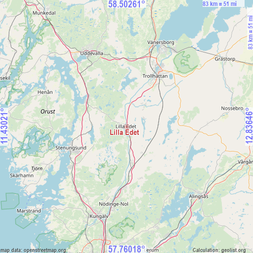
Lilla Edet GPS coordinates[2]
58° 7' 59.988" North, 12° 7' 59.988" East
| Map corner | latitude | longitude |
|---|---|---|
| Upper-left | 58.50261°, | 11.43021° |
| Center: | 58.13333°, | 12.13333° |
| Lower-right: | 57.76018°, | 12.83646° |
| Map W x H: | 82.6×82.5 km | = 51.3×51.3mi |
| max Lat: | 67.85572° ⇑58.8% North |
| Lilla Edet: | 58.13333° |
| min Lat: | ⇓41.2% South 55.34337° |
| min Long | Lilla Edet | max Long |
| 11.1712° | 12.13333° | 24.13676° |
| W 6.9%⇐ | ⇒93.1% E |
Elevation
Elevation of Lilla Edet is 41 m = 135 ft, and this is 41.6 m = 136 ft below average elevation for this country.
| Max E: |
663 m = 2175 ft | 56% |
| Avg. | 82.6 m = 271 ft | |
| Lilla Edet | 41 m = 135 ft | |
Min E: |
-1 m = -3 ft | 44% |
See also: Sweden elevation on elevation.city.
Geographical zone
Lilla Edet is located in North temperate zone (between Tropic of Cancer and the Arctic Circle). Distance of this North polar circle is 937.4 km =582.5 mi to North.| Distance of | km | miles | from Lilla Edet |
|---|---|---|---|
| North Pole | 3543.2 | 2201.6 | to North |
| Arctic Circle | 937.4 | 582.5 | to North |
| Tropic Cancer | 3857.9 | 2397.2 | to South |
| Equator | 6463.8 | 4016.4 | to South |


Nearby cities:
15 places around Lilla Edet: (largest is in red/bold)
• Göta
3.2 km =2 mi,  159°
159°
• Ljungskile
16.1 km =10 mi,  309°
309°
• Lödöse
11.6 km =7.2 mi,  172°
172°
• Sjuntorp
8.9 km =5.5 mi,  33°
33°
• Skepplanda
17.1 km =10.6 mi, 166°
• Stenungsund
19.8 km =12.3 mi,  249°
249°
• Svanesund
18.5 km =11.5 mi,  273°
273°
• Sålanda
17.4 km =10.8 mi, 163°
• Tollered
20.5 km =12.7 mi,  185°
185°
• Trollhättan
19 km =11.8 mi, 28°
• Ucklum
12.1 km =7.5 mi,  242°
242°
• Upphärad
10.4 km =6.5 mi,  74°
74°
• Velanda
14.8 km =9.2 mi,  44°
44°
• Älvängen
19.4 km =12.1 mi,  181°
181°
• Ödsmål
17 km =10.6 mi,  257°
257°
Sources, notices
• [Note1] Compared only with cities in Sweden existing in our database
• [Src1] Map data: © OpenStreetMap contributors (CC-BY-SA)
• [Src2] Other city data from geonames.org with taken over terms of usage.
• [Src3] Geographical zone / Annual Mean Temperature by Robert A. Rohde @ Wikipedia
