Kungälv geodata
Kungälv (Västra Götaland) is a seat of a second-order administrative division; located in Sweden in Europe/Stockholm (GMT+2) time zone. With population of 24,101 people, there are 62 cities with bigger population in this country. Compared to other cities in Sweden, 62.7% of cities are located further ↑North; 95% of cities are located further →East and 84.8% of cities have higher elevation than Kungälv. Note1


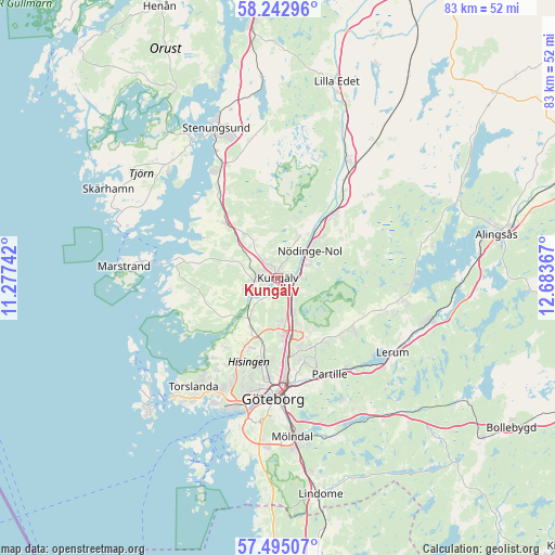
Kungälv GPS coordinates[2]
57° 52' 15.456" North, 11° 58' 49.944" East
| Map corner | latitude | longitude |
|---|---|---|
| Upper-left | 58.24296°, | 11.27742° |
| Center: | 57.87096°, | 11.98054° |
| Lower-right: | 57.49507°, | 12.68367° |
| Map W x H: | 83.2×83.2 km | = 51.7×51.7mi |
| max Lat: | 67.85572° ⇑62.7% North |
| Kungälv: | 57.87096° |
| min Lat: | ⇓37.3% South 55.34337° |
| min Long | Kungälv | max Long |
| 11.1712° | 11.98054° | 24.13676° |
| W 5%⇐ | ⇒95% E |
Elevation
Elevation of Kungälv is 13 m = 43 ft, and this is 69.6 m = 228 ft below average elevation for this country.
| Max E: |
663 m = 2175 ft | 84.8% |
| Avg. | 82.6 m = 271 ft | |
| Kungälv | 13 m = 43 ft | |
Min E: |
-1 m = -3 ft | 15.2% |
See also: Sweden elevation on elevation.city.
Geographical zone
Kungälv is located in North temperate zone (between Tropic of Cancer and the Arctic Circle). Distance of this North polar circle is 966.5 km =600.6 mi to North.| Distance of | km | miles | from Kungälv |
|---|---|---|---|
| North Pole | 3572.4 | 2219.8 | to North |
| Arctic Circle | 966.5 | 600.6 | to North |
| Tropic Cancer | 3828.7 | 2379 | to South |
| Equator | 6434.6 | 3998.3 | to South |


Nearby cities:
15 places around Kungälv: (largest is in red/bold)
• Alafors
8.4 km =5.2 mi,  43°
43°
• Angered
11.7 km =7.3 mi,  143°
143°
• Diseröd
6.7 km =4.2 mi,  23°
23°
• Eriksbo
11.6 km =7.2 mi,  161°
161°
• Gårdsten
7.9 km =4.9 mi, 158°
• Hammarkullen
10.6 km =6.6 mi, 161°
• Kode
11.1 km =6.9 mi,  316°
316°
• Kyrkobyn
8.7 km =5.4 mi,  205°
205°
• Kärna
11.9 km =7.4 mi,  258°
258°
• Lövgärdet
7.1 km =4.4 mi,  150°
150°
• Olofstorp
13.5 km =8.4 mi,  123°
123°
• Rannebergen
9.3 km =5.8 mi, 144°
• Surte
5.5 km =3.4 mi, 157°
• Tollered
11.3 km =7 mi, 38°
• Älvängen
12.9 km =8 mi, 40°
Sources, notices
• [Note1] Compared only with cities in Sweden existing in our database
• [Src1] Map data: © OpenStreetMap contributors (CC-BY-SA)
• [Src2] Other city data from geonames.org with taken over terms of usage.
• [Src3] Geographical zone / Annual Mean Temperature by Robert A. Rohde @ Wikipedia
