Tingsryd geodata
Tingsryd (Kronoberg) is a seat of a second-order administrative division; located in Sweden in Europe/Stockholm (GMT+2) time zone. With population of 3,087 people, there are 399 cities with bigger population in this country. Compared to other cities in Sweden, 83.8% of cities are located further ↑North; 51.1% of cities are located further →East and 79.1% of cities have lower elevation than Tingsryd. Note1


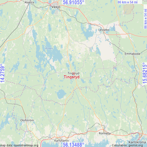
Tingsryd GPS coordinates[2]
56° 31' 28.92" North, 14° 58' 44.472" East
| Map corner | latitude | longitude |
|---|---|---|
| Upper-left | 56.91055°, | 14.2759° |
| Center: | 56.5247°, | 14.97902° |
| Lower-right: | 56.13488°, | 15.68215° |
| Map W x H: | 86.2×86.2 km | = 53.6×53.6mi |
| max Lat: | 67.85572° ⇑83.8% North |
| Tingsryd: | 56.5247° |
| min Lat: | ⇓16.2% South 55.34337° |
| min Long | Tingsryd | max Long |
| 11.1712° | 14.97902° | 24.13676° |
| W 48.9%⇐ | ⇒51.1% E |
Elevation
Elevation of Tingsryd is 140 m = 459 ft, and this is 57.4 m = 188 ft above average elevation for this country.
| Max E: |
663 m = 2175 ft | 20.9% |
| Tingsryd | 140 m 459 ft | |
| Avg. | 82.6 m = 271 ft | |
Min E: |
-1 m = -3 ft | 79.1% |
See also: Sweden elevation on elevation.city.
Geographical zone
Tingsryd is located in North temperate zone (between Tropic of Cancer and the Arctic Circle). Distance of this North polar circle is 1116.2 km =693.6 mi to North.| Distance of | km | miles | from Tingsryd |
|---|---|---|---|
| North Pole | 3722.1 | 2312.8 | to North |
| Arctic Circle | 1116.2 | 693.6 | to North |
| Tropic Cancer | 3679 | 2286 | to South |
| Equator | 6285 | 3905.3 | to South |


Nearby cities:
15 places around Tingsryd: (largest is in red/bold)
• Bräkne-Hoby
33.5 km =20.8 mi,  165°
165°
• Emmaboda
36.2 km =22.5 mi,  70°
70°
• Grimslöv
35.8 km =22.2 mi,  310°
310°
• Hovmantorp
30.8 km =19.1 mi,  18°
18°
• Hällaryd
36.1 km =22.4 mi,  182°
182°
• Ingelstad
25.3 km =15.7 mi,  351°
351°
• Kallinge
36.1 km =22.4 mi,  148°
148°
• Kyrkhult
31.1 km =19.3 mi,  231°
231°
• Lessebo
30.9 km =19.2 mi,  35°
35°
• Ryd
19.3 km =12 mi,  250°
250°
• Skruv
29.1 km =18.1 mi,  54°
54°
• Svängsta
31.5 km =19.6 mi,  204°
204°
• Urshult
12 km =7.5 mi,  274°
274°
• Väckelsång
12.7 km =7.9 mi,  342°
342°
• Åryd
33.7 km =20.9 mi,  0°
0°
Sources, notices
• [Note1] Compared only with cities in Sweden existing in our database
• [Src1] Map data: © OpenStreetMap contributors (CC-BY-SA)
• [Src2] Other city data from geonames.org with taken over terms of usage.
• [Src3] Geographical zone / Annual Mean Temperature by Robert A. Rohde @ Wikipedia
