Vedevåg geodata
Vedevåg (Örebro) is a populated place; located in Sweden in Europe/Stockholm (GMT+2) time zone. With population of 753 people, there are 1011 cities with bigger population in this country. Compared to other cities in Sweden, 66.9% of cities are located further ↓South; 53.5% of cities are located further ←West and 55.6% of cities have lower elevation than Vedevåg. Note1


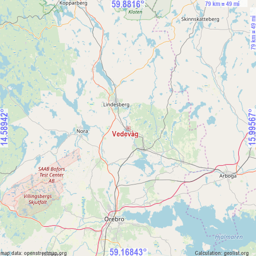
Vedevåg GPS coordinates[2]
59° 31' 36.84" North, 15° 17' 33.144" East
| Map corner | latitude | longitude |
|---|---|---|
| Upper-left | 59.8816°, | 14.58942° |
| Center: | 59.5269°, | 15.29254° |
| Lower-right: | 59.16843°, | 15.99567° |
| Map W x H: | 79.3×79.3 km | = 49.3×49.3mi |
| max Lat: | 67.85572° ⇑33.1% North |
| Vedevåg: | 59.5269° |
| min Lat: | ⇓66.9% South 55.34337° |
| min Long | Vedevåg | max Long |
| 11.1712° | 15.29254° | 24.13676° |
| W 53.5%⇐ | ⇒46.5% E |
Elevation
Elevation of Vedevåg is 60 m = 197 ft, and this is 22.6 m = 74 ft below average elevation for this country.
| Max E: |
663 m = 2175 ft | 44.4% |
| Avg. | 82.6 m = 271 ft | |
| Vedevåg | 60 m = 197 ft | |
Min E: |
-1 m = -3 ft | 55.6% |
See also: Sweden elevation on elevation.city.
Geographical zone
Vedevåg is located in North temperate zone (between Tropic of Cancer and the Arctic Circle). Distance of this North polar circle is 782.4 km =486.2 mi to North.| Distance of | km | miles | from Vedevåg |
|---|---|---|---|
| North Pole | 3388.3 | 2105.4 | to North |
| Arctic Circle | 782.4 | 486.2 | to North |
| Tropic Cancer | 4012.9 | 2493.5 | to South |
| Equator | 6618.8 | 4112.7 | to South |


Nearby cities:
15 places around Vedevåg: (largest is in red/bold)
• Ekeby-Almby
29.8 km =18.5 mi,  175°
175°
• Fellingsbro
19.4 km =12.1 mi,  122°
122°
• Frövi
7.9 km =4.9 mi,  148°
148°
• Garphyttan
31.6 km =19.6 mi,  218°
218°
• Glanshammar
24.2 km =15 mi,  165°
165°
• Gyttorp
18.5 km =11.5 mi,  262°
262°
• Hovsta
20.1 km =12.5 mi,  192°
192°
• Kolsva
31.5 km =19.6 mi,  75°
75°
• Latorpsbruk
33.3 km =20.7 mi,  211°
211°
• Lindesberg
8 km =5 mi,  334°
334°
• Nora
14.3 km =8.9 mi,  266°
266°
• Rinkaby
17.7 km =11 mi,  112°
112°
• Storå
22.7 km =14.1 mi,  336°
336°
• Ölmbrotorp
15.2 km =9.4 mi, 190°
• Örebro
28.5 km =17.7 mi, 189°
Sources, notices
• [Note1] Compared only with cities in Sweden existing in our database
• [Src1] Map data: © OpenStreetMap contributors (CC-BY-SA)
• [Src2] Other city data from geonames.org with taken over terms of usage.
• [Src3] Geographical zone / Annual Mean Temperature by Robert A. Rohde @ Wikipedia
