Östhammar geodata
Östhammar (Uppsala) is a seat of a second-order administrative division; located in Sweden in Europe/Stockholm (GMT+2) time zone. With population of 4,726 people, there are 288 cities with bigger population in this country. Compared to other cities in Sweden, 76.6% of cities are located further ↓South; 89.6% of cities are located further ←West and 95.4% of cities have higher elevation than Östhammar. Note1


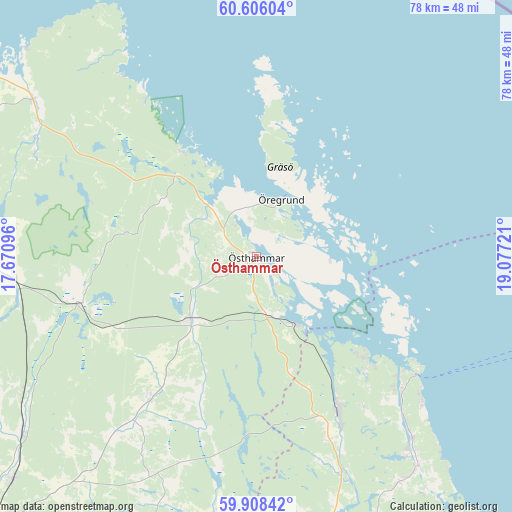
Östhammar GPS coordinates[2]
60° 15' 32.724" North, 18° 22' 26.688" East
| Map corner | latitude | longitude |
|---|---|---|
| Upper-left | 60.60604°, | 17.67096° |
| Center: | 60.25909°, | 18.37408° |
| Lower-right: | 59.90842°, | 19.07721° |
| Map W x H: | 77.6×77.6 km | = 48.2×48.2mi |
| max Lat: | 67.85572° ⇑23.4% North |
| Östhammar: | 60.25909° |
| min Lat: | ⇓76.6% South 55.34337° |
| min Long | Östhammar | max Long |
| 11.1712° | 18.37408° | 24.13676° |
| W 89.6%⇐ | ⇒10.4% E |
Elevation
Elevation of Östhammar is 5 m = 16 ft, and this is 77.6 m = 255 ft below average elevation for this country.
| Max E: |
663 m = 2175 ft | 95.4% |
| Avg. | 82.6 m = 271 ft | |
| Östhammar | 5 m = 16 ft | |
Min E: |
-1 m = -3 ft | 4.6% |
See also: Sweden elevation on elevation.city.
Geographical zone
Östhammar is located in North temperate zone (between Tropic of Cancer and the Arctic Circle). Distance of this North polar circle is 701 km =435.6 mi to North.| Distance of | km | miles | from Östhammar |
|---|---|---|---|
| North Pole | 3306.9 | 2054.8 | to North |
| Arctic Circle | 701 | 435.6 | to North |
| Tropic Cancer | 4094.3 | 2544.1 | to South |
| Equator | 6700.2 | 4163.3 | to South |


Nearby cities:
15 places around Östhammar: (largest is in red/bold)
• Alunda
1.7 km =1.1 mi,  59°
59°
• Alunda
26.8 km =16.7 mi,  216°
216°
• Anneberg
3 km =1.9 mi,  129°
129°
• Arnö
21.4 km =13.3 mi,  137°
137°
• Boda
1.1 km =0.7 mi,  153°
153°
• Gimo
14.2 km =8.8 mi,  227°
227°
• Hallstavik
26.4 km =16.4 mi, 151°
• Knutby
39.4 km =24.5 mi,  188°
188°
• Marieberg
7.5 km =4.7 mi,  112°
112°
• Skänninge
36.7 km =22.8 mi,  170°
170°
• Tobo
39.6 km =24.6 mi,  269°
269°
• Älmsta
40.2 km =25 mi, 144°
• Örbyhus
37.3 km =23.2 mi,  264°
264°
• Öregrund
8.9 km =5.5 mi,  21°
21°
• Österbybruk
27 km =16.8 mi, 255°
Sources, notices
• [Note1] Compared only with cities in Sweden existing in our database
• [Src1] Map data: © OpenStreetMap contributors (CC-BY-SA)
• [Src2] Other city data from geonames.org with taken over terms of usage.
• [Src3] Geographical zone / Annual Mean Temperature by Robert A. Rohde @ Wikipedia
